Colipa geodata
Colipa (Veracruz) is a seat of a second-order administrative division; located in Mexico in America/Mexico_City (GMT-6) time zone. With population of 2,489 people, there are 3550 cities with bigger population in this country. Compared to other cities in Mexico, 55.5% of cities are located further ↓South; 78.1% of cities are located further ←West and 75.9% of cities have higher elevation than Colipa. Note1


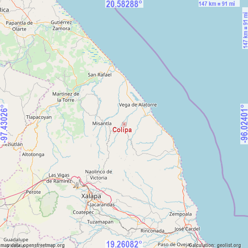
Colipa GPS coordinates[2]
19° 55' 23.628" North, 96° 43' 37.668" West
| Map corner | latitude | longitude |
|---|---|---|
| Upper-left | 20.58288°, | -97.43026° |
| Center: | 19.92323°, | -96.72713° |
| Lower-right: | 19.26082°, | -96.02401° |
| Map W x H: | 147×147 km | = 91.3×91.3mi |
| max Lat: | 32.7° ⇑44.5% North |
| Colipa: | 19.92323° |
| min Lat: | ⇓55.5% South 14.53588° |
| min Long | Colipa | max Long |
| -117.105° | -96.72713° | -86.73105° |
| W 78.1%⇐ | ⇒21.9% E |
Elevation
Elevation of Colipa is 193 m = 633 ft, and this is 1060.7 m = 3480 ft below average elevation for this country.
| Max E: |
3497 m = 11473 ft | 75.9% |
| Avg. | 1253.7 m = 4113 ft | |
| Colipa | 193 m = 633 ft | |
Min E: |
-1 m = -3 ft | 24.1% |
See also: Mexico elevation on elevation.city.
Geographical zone
Colipa is located in North Torrid zone (between Equator and Tropic of Cancer). Distance of this Northern Tropic circle is 390.7 km =242.8 mi to North.| Distance of | km | miles | from Colipa |
|---|---|---|---|
| North Pole | 7791.8 | 4841.6 | to North |
| Arctic Circle | 5185.9 | 3222.4 | to North |
| Tropic Cancer | 390.7 | 242.8 | to North |
| Equator | 2215.3 | 1376.5 | to South |


Nearby cities:
15 places around Colipa: (largest is in red/bold)
• Arroyo Frío
6.1 km =3.8 mi,  318°
318°
• Cristóbal Hidalgo
8.7 km =5.4 mi,  201°
201°
• Cuautitlán del Parral
8.8 km =5.5 mi,  183°
183°
• Dos Arroyos
6.6 km =4.1 mi,  162°
162°
• El Chaparral
9.8 km =6.1 mi,  125°
125°
• El Ciervo
12.6 km =7.8 mi,  336°
336°
• Juchique de Ferrer
9.9 km =6.2 mi, 159°
• La Reforma (Kilómetro 9)
9.5 km =5.9 mi,  245°
245°
• Leona Vicario
10.9 km =6.8 mi,  225°
225°
• Loma del Cojolite
11.5 km =7.1 mi,  300°
300°
• Misantla
13.1 km =8.1 mi,  273°
273°
• Plan de la Vega
8.4 km =5.2 mi, 295°
• Venustiano Carranza
8.9 km =5.5 mi,  256°
256°
• Villa Emilio Carranza
13.2 km =8.2 mi,  66°
66°
• Yecuatla
8.3 km =5.2 mi,  220°
220°
Sources, notices
• [Note1] Compared only with cities in Mexico existing in our database
• [Src1] Map data: © OpenStreetMap contributors (CC-BY-SA)
• [Src2] Other city data from geonames.org with taken over terms of usage.
• [Src3] Geographical zone / Annual Mean Temperature by Robert A. Rohde @ Wikipedia
