Las Paredes geodata
Las Paredes (Veracruz) is a populated place; located in Mexico in America/Mexico_City (GMT-6) time zone. With population of 597 people, there are 14400 cities with bigger population in this country. Compared to other cities in Mexico, 52.6% of cities are located further ↓South; 76.8% of cities are located further ←West and 62.8% of cities have lower elevation than Las Paredes. Note1


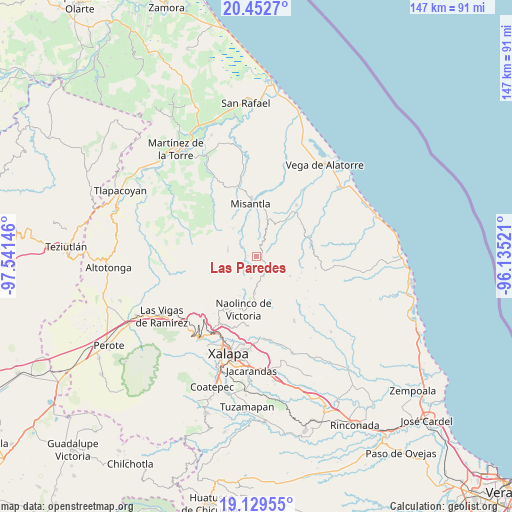
Las Paredes GPS coordinates[2]
19° 47' 33" North, 96° 50' 17.988" West
| Map corner | latitude | longitude |
|---|---|---|
| Upper-left | 20.4527°, | -97.54146° |
| Center: | 19.7925°, | -96.83833° |
| Lower-right: | 19.12955°, | -96.13521° |
| Map W x H: | 147.1×147.1 km | = 91.4×91.4mi |
| max Lat: | 32.7° ⇑47.4% North |
| Las Paredes: | 19.7925° |
| min Lat: | ⇓52.6% South 14.53588° |
| min Long | Las Paredes | max Long |
| -117.105° | -96.83833° | -86.73105° |
| W 76.8%⇐ | ⇒23.2% E |
Elevation
Elevation of Las Paredes is 1775 m = 5823 ft, and this is 521.3 m = 1710 ft above average elevation for this country.
| Max E: |
3497 m = 11473 ft | 37.2% |
| Las Paredes | 1775 m 5823 ft | |
| Avg. | 1253.7 m = 4113 ft | |
Min E: |
-1 m = -3 ft | 62.8% |
See also: Mexico elevation on elevation.city.
Geographical zone
Las Paredes is located in North Torrid zone (between Equator and Tropic of Cancer). Distance of this Northern Tropic circle is 405.2 km =251.8 mi to North.| Distance of | km | miles | from Las Paredes |
|---|---|---|---|
| North Pole | 7806.3 | 4850.6 | to North |
| Arctic Circle | 5200.5 | 3231.4 | to North |
| Tropic Cancer | 405.2 | 251.8 | to North |
| Equator | 2200.7 | 1367.5 | to South |


Nearby cities:
15 places around Las Paredes: (largest is in red/bold)
• Acatlán
10.7 km =6.6 mi,  182°
182°
• Chiconquiaco
6 km =3.7 mi,  159°
159°
• Cristóbal Hidalgo
10.6 km =6.6 mi,  52°
52°
• El Huérfano
11.3 km =7 mi,  120°
120°
• La Reforma (Kilómetro 9)
11 km =6.8 mi,  16°
16°
• Landero y Coss
6.6 km =4.1 mi,  192°
192°
• Leona Vicario
7.9 km =4.9 mi,  29°
29°
• Manuel Gutiérrez Nájera
2.4 km =1.5 mi,  271°
271°
• Miahuatlán
10 km =6.2 mi,  199°
199°
• Paso Blanco
9.1 km =5.7 mi,  336°
336°
• Pueblo Viejo
4.5 km =2.8 mi,  304°
304°
• Salvador Díaz Mirón
3.7 km =2.3 mi,  258°
258°
• Tenochtitlán
8.3 km =5.2 mi,  282°
282°
• Vicente Guerrero
10.4 km =6.5 mi,  319°
319°
• Yecuatla
10.3 km =6.4 mi,  37°
37°
Sources, notices
• [Note1] Compared only with cities in Mexico existing in our database
• [Src1] Map data: © OpenStreetMap contributors (CC-BY-SA)
• [Src2] Other city data from geonames.org with taken over terms of usage.
• [Src3] Geographical zone / Annual Mean Temperature by Robert A. Rohde @ Wikipedia
