Cristóbal Hidalgo geodata
Cristóbal Hidalgo (Veracruz) is a populated place; located in Mexico in America/Mexico_City (GMT-6) time zone. With population of 949 people, there are 9178 cities with bigger population in this country. Compared to other cities in Mexico, 54.1% of cities are located further ↓South; 77.8% of cities are located further ←West and 67% of cities have higher elevation than Cristóbal Hidalgo. Note1


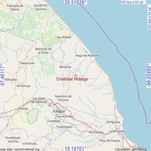
Cristóbal Hidalgo GPS coordinates[2]
19° 51' 1.152" North, 96° 45' 28.944" West
| Map corner | latitude | longitude |
|---|---|---|
| Upper-left | 20.51028°, | -97.46117° |
| Center: | 19.85032°, | -96.75804° |
| Lower-right: | 19.18761°, | -96.05492° |
| Map W x H: | 147.1×147.1 km | = 91.4×91.4mi |
| max Lat: | 32.7° ⇑45.9% North |
| Cristóbal Hidalgo: | 19.85032° |
| min Lat: | ⇓54.1% South 14.53588° |
| min Long | Cristóbal Hida | max Long |
| -117.105° | -96.75804° | -86.73105° |
| W 77.8%⇐ | ⇒22.2% E |
Elevation
Elevation of Cristóbal Hidalgo is 584 m = 1916 ft, and this is 669.7 m = 2197 ft below average elevation for this country.
| Max E: |
3497 m = 11473 ft | 67% |
| Avg. | 1253.7 m = 4113 ft | |
| Cristóbal Hidalgo | 584 m = 1916 ft | |
Min E: |
-1 m = -3 ft | 33% |
See also: Mexico elevation on elevation.city.
Geographical zone
Cristóbal Hidalgo is located in North Torrid zone (between Equator and Tropic of Cancer). Distance of this Northern Tropic circle is 398.8 km =247.8 mi to North.| Distance of | km | miles | from Cristóbal Hidalgo |
|---|---|---|---|
| North Pole | 7799.9 | 4846.6 | to North |
| Arctic Circle | 5194 | 3227.4 | to North |
| Tropic Cancer | 398.8 | 247.8 | to North |
| Equator | 2207.1 | 1371.4 | to South |


Nearby cities:
15 places around Cristóbal Hidalgo: (largest is in red/bold)
• Colipa
8.7 km =5.4 mi,  21°
21°
• Cuautitlán del Parral
2.8 km =1.7 mi,  104°
104°
• Dos Arroyos
5.6 km =3.5 mi,  70°
70°
• El Chaparral
11.4 km =7.1 mi,  78°
78°
• El Huérfano
12.2 km =7.6 mi,  173°
173°
• Juchique de Ferrer
6.7 km =4.2 mi, 99°
• La Reforma (Kilómetro 9)
6.8 km =4.2 mi,  307°
307°
• La Sombra
12 km =7.5 mi,  157°
157°
• Las Paredes
10.6 km =6.6 mi,  232°
232°
• Leona Vicario
4.5 km =2.8 mi,  275°
275°
• Manuel Gutiérrez Nájera
12.5 km =7.8 mi,  239°
239°
• Paso Blanco
12.2 km =7.6 mi, 279°
• Plan de la Vega
12.5 km =7.8 mi,  339°
339°
• Venustiano Carranza
8.1 km =5 mi,  318°
318°
• Yecuatla
2.8 km =1.7 mi, 309°
Sources, notices
• [Note1] Compared only with cities in Mexico existing in our database
• [Src1] Map data: © OpenStreetMap contributors (CC-BY-SA)
• [Src2] Other city data from geonames.org with taken over terms of usage.
• [Src3] Geographical zone / Annual Mean Temperature by Robert A. Rohde @ Wikipedia
