Plan de la Vega geodata
Plan de la Vega (Veracruz) is a populated place; located in Mexico in America/Mexico_City (GMT-6) time zone. With population of 641 people, there are 13506 cities with bigger population in this country. Compared to other cities in Mexico, 56.1% of cities are located further ↓South; 77.2% of cities are located further ←West and 75% of cities have higher elevation than Plan de la Vega. Note1


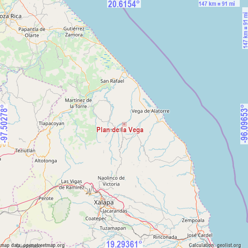
Plan de la Vega GPS coordinates[2]
19° 57' 21.204" North, 96° 47' 58.74" West
| Map corner | latitude | longitude |
|---|---|---|
| Upper-left | 20.6154°, | -97.50278° |
| Center: | 19.95589°, | -96.79965° |
| Lower-right: | 19.29361°, | -96.09653° |
| Map W x H: | 147×147 km | = 91.3×91.3mi |
| max Lat: | 32.7° ⇑43.9% North |
| Plan de la Vega: | 19.95589° |
| min Lat: | ⇓56.1% South 14.53588° |
| min Long | Plan de la Vega | max Long |
| -117.105° | -96.79965° | -86.73105° |
| W 77.2%⇐ | ⇒22.8% E |
Elevation
Elevation of Plan de la Vega is 223 m = 732 ft, and this is 1030.7 m = 3382 ft below average elevation for this country.
| Max E: |
3497 m = 11473 ft | 75% |
| Avg. | 1253.7 m = 4113 ft | |
| Plan de la Vega | 223 m = 732 ft | |
Min E: |
-1 m = -3 ft | 25% |
See also: Mexico elevation on elevation.city.
Geographical zone
Plan de la Vega is located in North Torrid zone (between Equator and Tropic of Cancer). Distance of this Northern Tropic circle is 387 km =240.5 mi to North.| Distance of | km | miles | from Plan de la Vega |
|---|---|---|---|
| North Pole | 7788.2 | 4839.4 | to North |
| Arctic Circle | 5182.3 | 3220.1 | to North |
| Tropic Cancer | 387 | 240.5 | to North |
| Equator | 2218.9 | 1378.8 | to South |


Nearby cities:
15 places around Plan de la Vega: (largest is in red/bold)
• Arroyo Frío
3.7 km =2.3 mi,  75°
75°
• Arroyo Hondo
10.8 km =6.7 mi,  314°
314°
• Colipa
8.4 km =5.2 mi,  115°
115°
• Cristóbal Hidalgo
12.5 km =7.8 mi,  159°
159°
• El Ciervo
8.3 km =5.2 mi,  18°
18°
• La Martinica
12.8 km =8 mi,  329°
329°
• La Primavera
9.9 km =6.2 mi,  298°
298°
• La Reforma (Kilómetro 9)
7.7 km =4.8 mi,  187°
187°
• Leona Vicario
11.3 km =7 mi,  180°
180°
• Loma del Cojolite
3.2 km =2 mi, 313°
• Misantla
6.2 km =3.9 mi,  242°
242°
• Paso Blanco
12.4 km =7.7 mi,  218°
218°
• Santa Cruz Hidalgo
8.5 km =5.3 mi,  278°
278°
• Venustiano Carranza
5.8 km =3.6 mi, 190°
• Yecuatla
10.2 km =6.3 mi,  167°
167°
Sources, notices
• [Note1] Compared only with cities in Mexico existing in our database
• [Src1] Map data: © OpenStreetMap contributors (CC-BY-SA)
• [Src2] Other city data from geonames.org with taken over terms of usage.
• [Src3] Geographical zone / Annual Mean Temperature by Robert A. Rohde @ Wikipedia
