Venustiano Carranza geodata
Venustiano Carranza (Veracruz) is a populated place; located in Mexico in America/Mexico_City (GMT-6) time zone. With population of 840 people, there are 10414 cities with bigger population in this country. Compared to other cities in Mexico, 55.1% of cities are located further ↓South; 77.1% of cities are located further ←West and 67.9% of cities have higher elevation than Venustiano Carranza. Note1


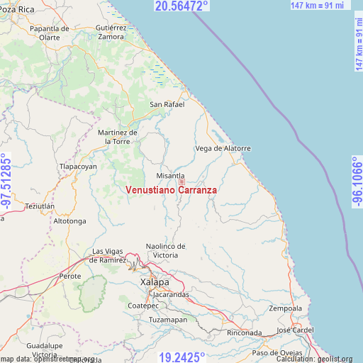
Venustiano Carranza GPS coordinates[2]
19° 54' 17.964" North, 96° 48' 34.992" West
| Map corner | latitude | longitude |
|---|---|---|
| Upper-left | 20.56472°, | -97.51285° |
| Center: | 19.90499°, | -96.80972° |
| Lower-right: | 19.2425°, | -96.1066° |
| Map W x H: | 147×147 km | = 91.3×91.3mi |
| max Lat: | 32.7° ⇑44.9% North |
| Venustiano Carranza: | 19.90499° |
| min Lat: | ⇓55.1% South 14.53588° |
| min Long | Venustiano Carr | max Long |
| -117.105° | -96.80972° | -86.73105° |
| W 77.1%⇐ | ⇒22.9% E |
Elevation
Elevation of Venustiano Carranza is 535 m = 1755 ft, and this is 718.7 m = 2358 ft below average elevation for this country.
| Max E: |
3497 m = 11473 ft | 67.9% |
| Avg. | 1253.7 m = 4113 ft | |
| Venustiano Carranza | 535 m = 1755 ft | |
Min E: |
-1 m = -3 ft | 32.1% |
See also: Mexico elevation on elevation.city.
Geographical zone
Venustiano Carranza is located in North Torrid zone (between Equator and Tropic of Cancer). Distance of this Northern Tropic circle is 392.7 km =244 mi to North.| Distance of | km | miles | from Venustiano Carranza |
|---|---|---|---|
| North Pole | 7793.8 | 4842.8 | to North |
| Arctic Circle | 5187.9 | 3223.6 | to North |
| Tropic Cancer | 392.7 | 244 | to North |
| Equator | 2213.2 | 1375.2 | to South |


Nearby cities:
15 places around Venustiano Carranza: (largest is in red/bold)
• Arroyo Frío
8.1 km =5 mi,  35°
35°
• Colipa
8.9 km =5.5 mi,  76°
76°
• Cristóbal Hidalgo
8.1 km =5 mi,  138°
138°
• Cuautitlán del Parral
10.6 km =6.6 mi,  129°
129°
• Dos Arroyos
11.5 km =7.1 mi,  111°
111°
• La Reforma (Kilómetro 9)
2 km =1.2 mi,  179°
179°
• Leona Vicario
5.7 km =3.5 mi,  170°
170°
• Loma del Cojolite
7.9 km =4.9 mi,  350°
350°
• Misantla
5.2 km =3.2 mi,  302°
302°
• Paso Blanco
7.8 km =4.8 mi,  238°
238°
• Plan de la Vega
5.8 km =3.6 mi,  10°
10°
• Pueblo Viejo
12 km =7.5 mi,  214°
214°
• Santa Cruz Hidalgo
10 km =6.2 mi,  313°
313°
• Vicente Guerrero
10.8 km =6.7 mi, 244°
• Yecuatla
5.4 km =3.4 mi, 142°
Sources, notices
• [Note1] Compared only with cities in Mexico existing in our database
• [Src1] Map data: © OpenStreetMap contributors (CC-BY-SA)
• [Src2] Other city data from geonames.org with taken over terms of usage.
• [Src3] Geographical zone / Annual Mean Temperature by Robert A. Rohde @ Wikipedia
