Yaxché de Peón geodata
Yaxché de Peón (Yucatán) is a populated place; located in Mexico in America/Merida (GMT-6) time zone. With population of 846 people, there are 10344 cities with bigger population in this country. Compared to other cities in Mexico, 77.1% of cities are located further ↓South; 97.7% of cities are located further ←West and 98.1% of cities have higher elevation than Yaxché de Peón. Note1


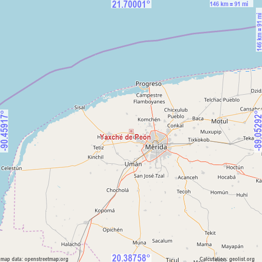
Yaxché de Peón GPS coordinates[2]
21° 2' 42.864" North, 89° 45' 21.744" West
| Map corner | latitude | longitude |
|---|---|---|
| Upper-left | 21.70001°, | -90.45917° |
| Center: | 21.04524°, | -89.75604° |
| Lower-right: | 20.38758°, | -89.05292° |
| Map W x H: | 145.9×145.9 km | = 90.7×90.7mi |
| max Lat: | 32.7° ⇑22.9% North |
| Yaxché de Peón: | 21.04524° |
| min Lat: | ⇓77.1% South 14.53588° |
| min Long | Yaxché de Peó | max Long |
| -117.105° | -89.75604° | -86.73105° |
| W 97.7%⇐ | ⇒2.3% E |
Elevation
Elevation of Yaxché de Peón is 8 m = 26 ft, and this is 1245.7 m = 4087 ft below average elevation for this country.
| Max E: |
3497 m = 11473 ft | 98.1% |
| Avg. | 1253.7 m = 4113 ft | |
| Yaxché de Peón | 8 m = 26 ft | |
Min E: |
-1 m = -3 ft | 1.9% |
See also: Mexico elevation on elevation.city.
Geographical zone
Yaxché de Peón is located in North Torrid zone (between Equator and Tropic of Cancer). Distance of this Northern Tropic circle is 265.9 km =165.2 mi to North.| Distance of | km | miles | from Yaxché de Peón |
|---|---|---|---|
| North Pole | 7667.1 | 4764.1 | to North |
| Arctic Circle | 5061.2 | 3144.9 | to North |
| Tropic Cancer | 265.9 | 165.2 | to North |
| Equator | 2340 | 1454 | to South |


Nearby cities:
15 places around Yaxché de Peón: (largest is in red/bold)
• Caucel
6.4 km =4 mi,  121°
121°
• Cosgaya
7.9 km =4.9 mi,  41°
41°
• Dzityá
8.1 km =5 mi,  84°
84°
• Hunucmá
12.8 km =8 mi,  255°
255°
• Itzincab Palomeque
15.5 km =9.6 mi,  157°
157°
• Komchén
11.7 km =7.3 mi,  56°
56°
• La Ceiba
14.1 km =8.8 mi,  68°
68°
• Opichen
13.3 km =8.3 mi,  143°
143°
• Oxcum
11.1 km =6.9 mi,  183°
183°
• Sierra Papacal
9.3 km =5.8 mi,  16°
16°
• Tamanché
15.8 km =9.8 mi,  48°
48°
• Texan de Palomeque
14.4 km =8.9 mi,  213°
213°
• Tizcacal Opichen
12 km =7.5 mi, 158°
• Ucú
1.9 km =1.2 mi, 142°
• Xcanatún
13.5 km =8.4 mi, 75°
Sources, notices
• [Note1] Compared only with cities in Mexico existing in our database
• [Src1] Map data: © OpenStreetMap contributors (CC-BY-SA)
• [Src2] Other city data from geonames.org with taken over terms of usage.
• [Src3] Geographical zone / Annual Mean Temperature by Robert A. Rohde @ Wikipedia
