Opichen geodata
Opichen (Yucatán) is a populated place; located in Mexico in America/Merida (GMT-6) time zone. With population of 521 people, there are 16186 cities with bigger population in this country. Compared to other cities in Mexico, 75.7% of cities are located further ↓South; 97.8% of cities are located further ←West and 95.7% of cities have higher elevation than Opichen. Note1


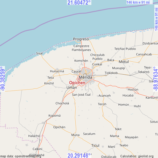
Opichen GPS coordinates[2]
20° 56' 58.308" North, 89° 40' 46.056" West
| Map corner | latitude | longitude |
|---|---|---|
| Upper-left | 21.60472°, | -90.38259° |
| Center: | 20.94953°, | -89.67946° |
| Lower-right: | 20.29146°, | -88.97634° |
| Map W x H: | 146×146 km | = 90.7×90.7mi |
| max Lat: | 32.7° ⇑24.3% North |
| Opichen: | 20.94953° |
| min Lat: | ⇓75.7% South 14.53588° |
| min Long | Opichen | max Long |
| -117.105° | -89.67946° | -86.73105° |
| W 97.8%⇐ | ⇒2.2% E |
Elevation
Elevation of Opichen is 12 m = 39 ft, and this is 1241.7 m = 4074 ft below average elevation for this country.
| Max E: |
3497 m = 11473 ft | 95.7% |
| Avg. | 1253.7 m = 4113 ft | |
| Opichen | 12 m = 39 ft | |
Min E: |
-1 m = -3 ft | 4.3% |
See also: Mexico elevation on elevation.city.
Geographical zone
Opichen is located in North Torrid zone (between Equator and Tropic of Cancer). Distance of this Northern Tropic circle is 276.5 km =171.8 mi to North.| Distance of | km | miles | from Opichen |
|---|---|---|---|
| North Pole | 7677.7 | 4770.7 | to North |
| Arctic Circle | 5071.8 | 3151.5 | to North |
| Tropic Cancer | 276.5 | 171.8 | to North |
| Equator | 2329.4 | 1447.4 | to South |


Nearby cities:
15 places around Opichen: (largest is in red/bold)
• Caucel
7.7 km =4.8 mi,  341°
341°
• Dzityá
11.4 km =7.1 mi,  0°
0°
• Dzununcan
9.8 km =6.1 mi,  164°
164°
• Itzincab Palomeque
4.2 km =2.6 mi,  207°
207°
• Kanasín
12.6 km =7.8 mi,  97°
97°
• Leona Vicario
9.3 km =5.8 mi,  118°
118°
• Mérida
7.1 km =4.4 mi,  66°
66°
• Oxcum
8.6 km =5.3 mi,  266°
266°
• Santa Cruz Palomeque
8.1 km =5 mi, 160°
• Tahdzibichen
11.1 km =6.9 mi,  129°
129°
• Ticimul
7.6 km =4.7 mi,  183°
183°
• Tizcacal Opichen
3.7 km =2.3 mi,  260°
260°
• Ucú
11.3 km =7 mi,  323°
323°
• Uman
10.2 km =6.3 mi,  222°
222°
• Xmatkuíl
11.4 km =7.1 mi,  150°
150°
Sources, notices
• [Note1] Compared only with cities in Mexico existing in our database
• [Src1] Map data: © OpenStreetMap contributors (CC-BY-SA)
• [Src2] Other city data from geonames.org with taken over terms of usage.
• [Src3] Geographical zone / Annual Mean Temperature by Robert A. Rohde @ Wikipedia
