Xcanatún geodata
Xcanatún (Yucatán) is a populated place; located in Mexico in America/Merida (GMT-6) time zone. With population of 1,495 people, there are 5773 cities with bigger population in this country. Compared to other cities in Mexico, 77.6% of cities are located further ↓South; 97.9% of cities are located further ←West and 98.1% of cities have higher elevation than Xcanatún. Note1


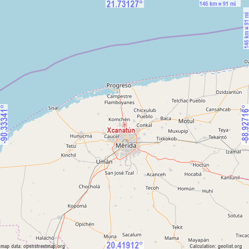
Xcanatún GPS coordinates[2]
21° 4' 35.904" North, 89° 37' 49.008" West
| Map corner | latitude | longitude |
|---|---|---|
| Upper-left | 21.73127°, | -90.33341° |
| Center: | 21.07664°, | -89.63028° |
| Lower-right: | 20.41912°, | -88.92716° |
| Map W x H: | 145.9×145.9 km | = 90.7×90.7mi |
| max Lat: | 32.7° ⇑22.4% North |
| Xcanatún: | 21.07664° |
| min Lat: | ⇓77.6% South 14.53588° |
| min Long | Xcanatún | max Long |
| -117.105° | -89.63028° | -86.73105° |
| W 97.9%⇐ | ⇒2.1% E |
Elevation
Elevation of Xcanatún is 8 m = 26 ft, and this is 1245.7 m = 4087 ft below average elevation for this country.
| Max E: |
3497 m = 11473 ft | 98.1% |
| Avg. | 1253.7 m = 4113 ft | |
| Xcanatún | 8 m = 26 ft | |
Min E: |
-1 m = -3 ft | 1.9% |
See also: Mexico elevation on elevation.city.
Geographical zone
Xcanatún is located in North Torrid zone (between Equator and Tropic of Cancer). Distance of this Northern Tropic circle is 262.4 km =163 mi to North.| Distance of | km | miles | from Xcanatún |
|---|---|---|---|
| North Pole | 7663.6 | 4761.9 | to North |
| Arctic Circle | 5057.7 | 3142.7 | to North |
| Tropic Cancer | 262.4 | 163 | to North |
| Equator | 2343.5 | 1456.2 | to South |


Nearby cities:
15 places around Xcanatún: (largest is in red/bold)
• Caucel
10.2 km =6.3 mi,  228°
228°
• Chablekal
5.9 km =3.7 mi,  67°
67°
• Cholul
8.3 km =5.2 mi,  117°
117°
• Conkal
11.5 km =7.1 mi,  91°
91°
• Cosgaya
8.2 km =5.1 mi,  287°
287°
• Dzityá
5.7 km =3.5 mi,  241°
241°
• Komchén
4.5 km =2.8 mi,  311°
311°
• La Ceiba
1.6 km =1 mi,  3°
3°
• Mérida
11.3 km =7 mi,  173°
173°
• San Ignacio
9.6 km =6 mi,  343°
343°
• Sierra Papacal
11.7 km =7.3 mi,  297°
297°
• Sitpach
12.6 km =7.8 mi, 116°
• Tamanché
7 km =4.3 mi,  350°
350°
• Ucú
12.9 km =8 mi,  247°
247°
• Xcunyá
6.5 km =4 mi,  15°
15°
Sources, notices
• [Note1] Compared only with cities in Mexico existing in our database
• [Src1] Map data: © OpenStreetMap contributors (CC-BY-SA)
• [Src2] Other city data from geonames.org with taken over terms of usage.
• [Src3] Geographical zone / Annual Mean Temperature by Robert A. Rohde @ Wikipedia
