Itzincab Palomeque geodata
Itzincab Palomeque (Yucatán) is a populated place; located in Mexico in America/Merida (GMT-6) time zone. With population of 5,013 people, there are 1840 cities with bigger population in this country. Compared to other cities in Mexico, 75.2% of cities are located further ↓South; 97.8% of cities are located further ←West and 97.5% of cities have higher elevation than Itzincab Palomeque. Note1


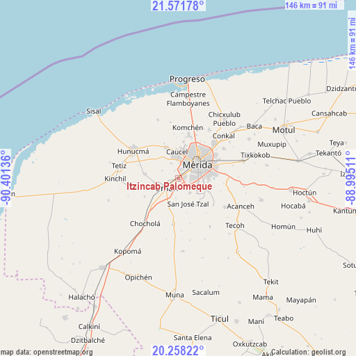
Itzincab Palomeque GPS coordinates[2]
20° 54' 59.184" North, 89° 41' 53.628" West
| Map corner | latitude | longitude |
|---|---|---|
| Upper-left | 21.57178°, | -90.40136° |
| Center: | 20.91644°, | -89.69823° |
| Lower-right: | 20.25822°, | -88.99511° |
| Map W x H: | 146.1×146.1 km | = 90.8×90.8mi |
| max Lat: | 32.7° ⇑24.8% North |
| Itzincab Palomeque: | 20.91644° |
| min Lat: | ⇓75.2% South 14.53588° |
| min Long | Itzincab Palome | max Long |
| -117.105° | -89.69823° | -86.73105° |
| W 97.8%⇐ | ⇒2.2% E |
Elevation
Elevation of Itzincab Palomeque is 9 m = 30 ft, and this is 1244.7 m = 4084 ft below average elevation for this country.
| Max E: |
3497 m = 11473 ft | 97.5% |
| Avg. | 1253.7 m = 4113 ft | |
| Itzincab Palomeque | 9 m = 30 ft | |
Min E: |
-1 m = -3 ft | 2.5% |
See also: Mexico elevation on elevation.city.
Geographical zone
Itzincab Palomeque is located in North Torrid zone (between Equator and Tropic of Cancer). Distance of this Northern Tropic circle is 280.2 km =174.1 mi to North.| Distance of | km | miles | from Itzincab Palomeque |
|---|---|---|---|
| North Pole | 7681.4 | 4773 | to North |
| Arctic Circle | 5075.5 | 3153.8 | to North |
| Tropic Cancer | 280.2 | 174.1 | to North |
| Equator | 2325.7 | 1445.1 | to South |


Nearby cities:
15 places around Itzincab Palomeque: (largest is in red/bold)
• Caucel
11 km =6.8 mi,  357°
357°
• Dzibikak
10.2 km =6.3 mi,  260°
260°
• Dzununcan
7.4 km =4.6 mi,  141°
141°
• Leona Vicario
10.1 km =6.3 mi,  94°
94°
• Mérida
10.7 km =6.6 mi,  52°
52°
• Opichen
4.2 km =2.6 mi,  27°
27°
• Oxcum
7.3 km =4.5 mi,  295°
295°
• San José Tzal
11 km =6.8 mi,  159°
159°
• Santa Cruz Palomeque
6.1 km =3.8 mi,  130°
130°
• Tahdzibichen
11 km =6.8 mi,  108°
108°
• Ticimul
4.2 km =2.6 mi, 158°
• Tizcacal Opichen
3.5 km =2.2 mi,  331°
331°
• Uman
6.3 km =3.9 mi,  232°
232°
• Xmatkuíl
9.8 km =6.1 mi, 129°
• Xtepen
11.5 km =7.1 mi,  204°
204°
Sources, notices
• [Note1] Compared only with cities in Mexico existing in our database
• [Src1] Map data: © OpenStreetMap contributors (CC-BY-SA)
• [Src2] Other city data from geonames.org with taken over terms of usage.
• [Src3] Geographical zone / Annual Mean Temperature by Robert A. Rohde @ Wikipedia
