Ucú geodata
Ucú (Yucatán) is a seat of a second-order administrative division; located in Mexico in America/Merida (GMT-6) time zone. With population of 2,601 people, there are 3409 cities with bigger population in this country. Compared to other cities in Mexico, 76.9% of cities are located further ↓South; 97.8% of cities are located further ←West and 97.5% of cities have higher elevation than Ucú. Note1


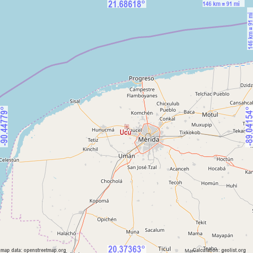
Ucú GPS coordinates[2]
21° 1' 52.86" North, 89° 44' 40.776" West
| Map corner | latitude | longitude |
|---|---|---|
| Upper-left | 21.68618°, | -90.44779° |
| Center: | 21.03135°, | -89.74466° |
| Lower-right: | 20.37363°, | -89.04154° |
| Map W x H: | 145.9×145.9 km | = 90.7×90.7mi |
| max Lat: | 32.7° ⇑23.1% North |
| Ucú: | 21.03135° |
| min Lat: | ⇓76.9% South 14.53588° |
| min Long | Ucú | max Long |
| -117.105° | -89.74466° | -86.73105° |
| W 97.8%⇐ | ⇒2.2% E |
Elevation
Elevation of Ucú is 9 m = 30 ft, and this is 1244.7 m = 4084 ft below average elevation for this country.
| Max E: |
3497 m = 11473 ft | 97.5% |
| Avg. | 1253.7 m = 4113 ft | |
| Ucú | 9 m = 30 ft | |
Min E: |
-1 m = -3 ft | 2.5% |
See also: Mexico elevation on elevation.city.
Geographical zone
Ucú is located in North Torrid zone (between Equator and Tropic of Cancer). Distance of this Northern Tropic circle is 267.5 km =166.2 mi to North.| Distance of | km | miles | from Ucú |
|---|---|---|---|
| North Pole | 7668.6 | 4765 | to North |
| Arctic Circle | 5062.7 | 3145.8 | to North |
| Tropic Cancer | 267.5 | 166.2 | to North |
| Equator | 2338.5 | 1453.1 | to South |


Nearby cities:
15 places around Ucú: (largest is in red/bold)
• Caucel
4.6 km =2.9 mi,  112°
112°
• Cosgaya
8.5 km =5.3 mi,  28°
28°
• Dzityá
7.2 km =4.5 mi,  71°
71°
• Hunucmá
13.7 km =8.5 mi,  263°
263°
• Itzincab Palomeque
13.7 km =8.5 mi,  159°
159°
• Komchén
11.7 km =7.3 mi,  46°
46°
• La Ceiba
13.7 km =8.5 mi,  60°
60°
• Mérida
14.6 km =9.1 mi,  115°
115°
• Opichen
11.3 km =7 mi,  143°
143°
• Oxcum
9.8 km =6.1 mi,  190°
190°
• Sierra Papacal
10.5 km =6.5 mi,  8°
8°
• Texan de Palomeque
13.9 km =8.6 mi,  221°
221°
• Tizcacal Opichen
10.2 km =6.3 mi, 162°
• Xcanatún
12.9 km =8 mi, 67°
• Yaxché de Peón
1.9 km =1.2 mi,  322°
322°
Sources, notices
• [Note1] Compared only with cities in Mexico existing in our database
• [Src1] Map data: © OpenStreetMap contributors (CC-BY-SA)
• [Src2] Other city data from geonames.org with taken over terms of usage.
• [Src3] Geographical zone / Annual Mean Temperature by Robert A. Rohde @ Wikipedia
