Tizcacal Opichen geodata
Tizcacal Opichen (Yucatán) is a populated place; located in Mexico in America/Merida (GMT-6) time zone. With population of 881 people, there are 9918 cities with bigger population in this country. Compared to other cities in Mexico, 75.6% of cities are located further ↓South; 97.8% of cities are located further ←West and 97% of cities have higher elevation than Tizcacal Opichen. Note1


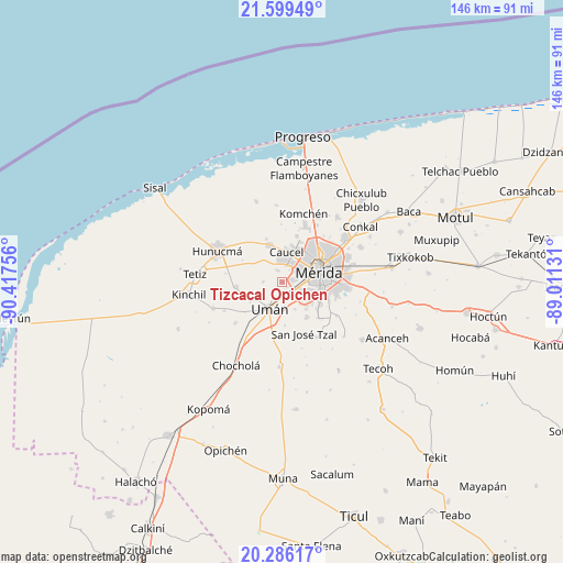
Tizcacal Opichen GPS coordinates[2]
20° 56' 39.372" North, 89° 42' 51.948" West
| Map corner | latitude | longitude |
|---|---|---|
| Upper-left | 21.59949°, | -90.41756° |
| Center: | 20.94427°, | -89.71443° |
| Lower-right: | 20.28617°, | -89.01131° |
| Map W x H: | 146×146 km | = 90.7×90.7mi |
| max Lat: | 32.7° ⇑24.4% North |
| Tizcacal Opichen: | 20.94427° |
| min Lat: | ⇓75.6% South 14.53588° |
| min Long | Tizcacal Opiche | max Long |
| -117.105° | -89.71443° | -86.73105° |
| W 97.8%⇐ | ⇒2.2% E |
Elevation
Elevation of Tizcacal Opichen is 10 m = 33 ft, and this is 1243.7 m = 4080 ft below average elevation for this country.
| Max E: |
3497 m = 11473 ft | 97% |
| Avg. | 1253.7 m = 4113 ft | |
| Tizcacal Opichen | 10 m = 33 ft | |
Min E: |
-1 m = -3 ft | 3% |
See also: Mexico elevation on elevation.city.
Geographical zone
Tizcacal Opichen is located in North Torrid zone (between Equator and Tropic of Cancer). Distance of this Northern Tropic circle is 277.1 km =172.2 mi to North.| Distance of | km | miles | from Tizcacal Opichen |
|---|---|---|---|
| North Pole | 7678.3 | 4771.1 | to North |
| Arctic Circle | 5072.4 | 3151.8 | to North |
| Tropic Cancer | 277.1 | 172.2 | to North |
| Equator | 2328.8 | 1447 | to South |


Nearby cities:
15 places around Tizcacal Opichen: (largest is in red/bold)
• Caucel
8 km =5 mi,  8°
8°
• Dzibikak
9.7 km =6 mi,  239°
239°
• Dzityá
12.5 km =7.8 mi,  17°
17°
• Dzununcan
10.9 km =6.8 mi,  144°
144°
• Itzincab Palomeque
3.5 km =2.2 mi,  151°
151°
• Leona Vicario
12.4 km =7.7 mi,  108°
108°
• Mérida
10.7 km =6.6 mi,  71°
71°
• Opichen
3.7 km =2.3 mi,  80°
80°
• Oxcum
4.9 km =3 mi,  271°
271°
• Santa Cruz Palomeque
9.5 km =5.9 mi, 138°
• Texan de Palomeque
12.4 km =7.7 mi, 266°
• Ticimul
7.7 km =4.8 mi,  155°
155°
• Ucú
10.2 km =6.3 mi,  342°
342°
• Uman
7.7 km =4.8 mi,  205°
205°
• Yaxché de Peón
12 km =7.5 mi, 338°
Sources, notices
• [Note1] Compared only with cities in Mexico existing in our database
• [Src1] Map data: © OpenStreetMap contributors (CC-BY-SA)
• [Src2] Other city data from geonames.org with taken over terms of usage.
• [Src3] Geographical zone / Annual Mean Temperature by Robert A. Rohde @ Wikipedia
