Yalkoba geodata
Yalkoba (Yucatán) is a populated place; located in Mexico in America/Merida (GMT-6) time zone. With population of 2,808 people, there are 3155 cities with bigger population in this country. Compared to other cities in Mexico, 73.2% of cities are located further ↓South; 99.7% of cities are located further ←West and 90.8% of cities have higher elevation than Yalkoba. Note1


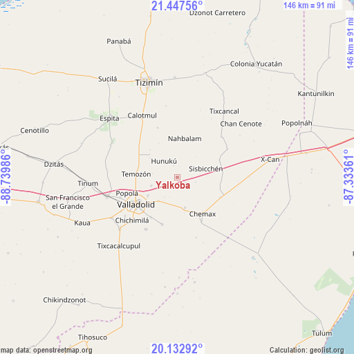
Yalkoba GPS coordinates[2]
20° 47' 30.012" North, 88° 2' 12.228" West
| Map corner | latitude | longitude |
|---|---|---|
| Upper-left | 21.44756°, | -88.73986° |
| Center: | 20.79167°, | -88.03673° |
| Lower-right: | 20.13292°, | -87.33361° |
| Map W x H: | 146.2×146.2 km | = 90.8×90.8mi |
| max Lat: | 32.7° ⇑26.8% North |
| Yalkoba: | 20.79167° |
| min Lat: | ⇓73.2% South 14.53588° |
| min Long | Yalkoba | max Long |
| -117.105° | -88.03673° | -86.73105° |
| W 99.7%⇐ | ⇒0.3% E |
Elevation
Elevation of Yalkoba is 22 m = 72 ft, and this is 1231.7 m = 4041 ft below average elevation for this country.
| Max E: |
3497 m = 11473 ft | 90.8% |
| Avg. | 1253.7 m = 4113 ft | |
| Yalkoba | 22 m = 72 ft | |
Min E: |
-1 m = -3 ft | 9.2% |
See also: Mexico elevation on elevation.city.
Geographical zone
Yalkoba is located in North Torrid zone (between Equator and Tropic of Cancer). Distance of this Northern Tropic circle is 294.1 km =182.7 mi to North.| Distance of | km | miles | from Yalkoba |
|---|---|---|---|
| North Pole | 7695.2 | 4781.6 | to North |
| Arctic Circle | 5089.4 | 3162.4 | to North |
| Tropic Cancer | 294.1 | 182.7 | to North |
| Equator | 2311.8 | 1436.5 | to South |


Nearby cities:
15 places around Yalkoba: (largest is in red/bold)
• Chechmil
7.8 km =4.8 mi,  105°
105°
• Chemax
18.3 km =11.4 mi,  145°
145°
• Dzalbay
5.1 km =3.2 mi,  340°
340°
• Hunuku
8.7 km =5.4 mi,  320°
320°
• Kanxoc
20.6 km =12.8 mi,  197°
197°
• Kuxeb
18.9 km =11.7 mi,  66°
66°
• Pocoboch
21.9 km =13.6 mi, 338°
• Popola
21.9 km =13.6 mi,  252°
252°
• Tahmuy
11.5 km =7.1 mi, 251°
• Temozon
17.2 km =10.7 mi,  274°
274°
• Tesoco
14.5 km =9 mi,  237°
237°
• Tikuch
12.6 km =7.8 mi,  218°
218°
• Tixhualactún
19.8 km =12.3 mi,  213°
213°
• Uspibil
4.2 km =2.6 mi,  125°
125°
• Valladolid
20.5 km =12.7 mi, 235°
Sources, notices
• [Note1] Compared only with cities in Mexico existing in our database
• [Src1] Map data: © OpenStreetMap contributors (CC-BY-SA)
• [Src2] Other city data from geonames.org with taken over terms of usage.
• [Src3] Geographical zone / Annual Mean Temperature by Robert A. Rohde @ Wikipedia
