Pocoboch geodata
Pocoboch (Yucatán) is a populated place; located in Mexico in America/Merida (GMT-6) time zone. With population of 809 people, there are 10801 cities with bigger population in this country. Compared to other cities in Mexico, 76.1% of cities are located further ↓South; 99.7% of cities are located further ←West and 89.4% of cities have higher elevation than Pocoboch. Note1


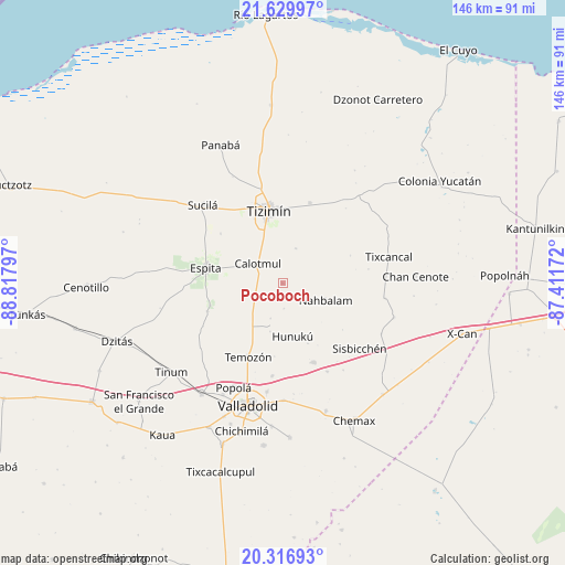
Pocoboch GPS coordinates[2]
20° 58' 29.604" North, 88° 6' 53.424" West
| Map corner | latitude | longitude |
|---|---|---|
| Upper-left | 21.62997°, | -88.81797° |
| Center: | 20.97489°, | -88.11484° |
| Lower-right: | 20.31693°, | -87.41172° |
| Map W x H: | 146×146 km | = 90.7×90.7mi |
| max Lat: | 32.7° ⇑23.9% North |
| Pocoboch: | 20.97489° |
| min Lat: | ⇓76.1% South 14.53588° |
| min Long | Pocoboch | max Long |
| -117.105° | -88.11484° | -86.73105° |
| W 99.7%⇐ | ⇒0.3% E |
Elevation
Elevation of Pocoboch is 26 m = 85 ft, and this is 1227.7 m = 4028 ft below average elevation for this country.
| Max E: |
3497 m = 11473 ft | 89.4% |
| Avg. | 1253.7 m = 4113 ft | |
| Pocoboch | 26 m = 85 ft | |
Min E: |
-1 m = -3 ft | 10.6% |
See also: Mexico elevation on elevation.city.
Geographical zone
Pocoboch is located in North Torrid zone (between Equator and Tropic of Cancer). Distance of this Northern Tropic circle is 273.7 km =170.1 mi to North.| Distance of | km | miles | from Pocoboch |
|---|---|---|---|
| North Pole | 7674.9 | 4769 | to North |
| Arctic Circle | 5069 | 3149.7 | to North |
| Tropic Cancer | 273.7 | 170.1 | to North |
| Equator | 2332.2 | 1449.2 | to South |


Nearby cities:
15 places around Pocoboch: (largest is in red/bold)
• Calotmul
8.2 km =5.1 mi,  308°
308°
• Chechmil
27.4 km =17 mi,  145°
145°
• Dzalbay
16.9 km =10.5 mi,  157°
157°
• Espita
20.3 km =12.6 mi,  281°
281°
• Holcá
20.6 km =12.8 mi, 309°
• Hunuku
13.9 km =8.6 mi,  169°
169°
• Kunche
20.8 km =12.9 mi,  250°
250°
• Nacuche
19.6 km =12.2 mi, 253°
• Sucopó
21.9 km =13.6 mi,  18°
18°
• Tahmuy
24.1 km =15 mi,  186°
186°
• Temozon
21 km =13 mi,  205°
205°
• Tixcancal
28.3 km =17.6 mi,  76°
76°
• Tizimín
19 km =11.8 mi,  348°
348°
• Uspibil
25.6 km =15.9 mi, 153°
• Yalkoba
21.9 km =13.6 mi, 158°
Sources, notices
• [Note1] Compared only with cities in Mexico existing in our database
• [Src1] Map data: © OpenStreetMap contributors (CC-BY-SA)
• [Src2] Other city data from geonames.org with taken over terms of usage.
• [Src3] Geographical zone / Annual Mean Temperature by Robert A. Rohde @ Wikipedia
