Tesoco geodata
Tesoco (Yucatán) is a populated place; located in Mexico in America/Merida (GMT-6) time zone. With population of 1,362 people, there are 6375 cities with bigger population in this country. Compared to other cities in Mexico, 72% of cities are located further ↓South; 99.6% of cities are located further ←West and 90% of cities have higher elevation than Tesoco. Note1


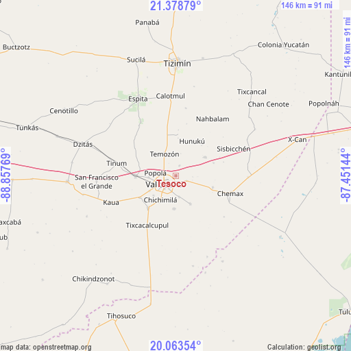
Tesoco GPS coordinates[2]
20° 43' 21.324" North, 88° 9' 16.416" West
| Map corner | latitude | longitude |
|---|---|---|
| Upper-left | 21.37879°, | -88.85769° |
| Center: | 20.72259°, | -88.15456° |
| Lower-right: | 20.06354°, | -87.45144° |
| Map W x H: | 146.2×146.2 km | = 90.8×90.8mi |
| max Lat: | 32.7° ⇑28% North |
| Tesoco: | 20.72259° |
| min Lat: | ⇓72% South 14.53588° |
| min Long | Tesoco | max Long |
| -117.105° | -88.15456° | -86.73105° |
| W 99.6%⇐ | ⇒0.40000000000001% E |
Elevation
Elevation of Tesoco is 24 m = 79 ft, and this is 1229.7 m = 4034 ft below average elevation for this country.
| Max E: |
3497 m = 11473 ft | 90% |
| Avg. | 1253.7 m = 4113 ft | |
| Tesoco | 24 m = 79 ft | |
Min E: |
-1 m = -3 ft | 10% |
See also: Mexico elevation on elevation.city.
Geographical zone
Tesoco is located in North Torrid zone (between Equator and Tropic of Cancer). Distance of this Northern Tropic circle is 301.8 km =187.5 mi to North.| Distance of | km | miles | from Tesoco |
|---|---|---|---|
| North Pole | 7702.9 | 4786.4 | to North |
| Arctic Circle | 5097 | 3167.1 | to North |
| Tropic Cancer | 301.8 | 187.5 | to North |
| Equator | 2304.1 | 1431.7 | to South |


Nearby cities:
15 places around Tesoco: (largest is in red/bold)
• Chichimila
12 km =7.5 mi,  212°
212°
• Dzalbay
16.3 km =10.1 mi,  40°
40°
• Dzitnup
12.6 km =7.8 mi,  228°
228°
• Ebtun
12.7 km =7.9 mi,  239°
239°
• Hunuku
15.9 km =9.9 mi,  25°
25°
• Kanxoc
13.3 km =8.3 mi,  153°
153°
• Pixoy
11.4 km =7.1 mi,  266°
266°
• Popola
8.7 km =5.4 mi,  277°
277°
• Tahmuy
4.3 km =2.7 mi,  18°
18°
• Temozon
10.3 km =6.4 mi,  331°
331°
• Tikuch
4.9 km =3 mi,  116°
116°
• Tixhualactún
8.8 km =5.5 mi,  172°
172°
• Valladolid
6 km =3.7 mi, 230°
• Xocen
13.9 km =8.6 mi,  184°
184°
• Yalkoba
14.5 km =9 mi,  57°
57°
Sources, notices
• [Note1] Compared only with cities in Mexico existing in our database
• [Src1] Map data: © OpenStreetMap contributors (CC-BY-SA)
• [Src2] Other city data from geonames.org with taken over terms of usage.
• [Src3] Geographical zone / Annual Mean Temperature by Robert A. Rohde @ Wikipedia
