Temozon geodata
Temozon (Yucatán) is a populated place; located in Mexico in America/Merida (GMT-6) time zone. With population of 6,553 people, there are 1429 cities with bigger population in this country. Compared to other cities in Mexico, 73.4% of cities are located further ↓South; 99.6% of cities are located further ←West and 90.4% of cities have higher elevation than Temozon. Note1


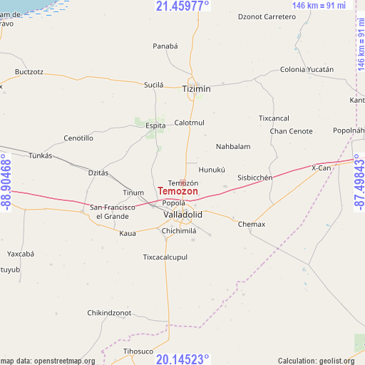
Temozon GPS coordinates[2]
20° 48' 14.148" North, 88° 12' 5.58" West
| Map corner | latitude | longitude |
|---|---|---|
| Upper-left | 21.45977°, | -88.90468° |
| Center: | 20.80393°, | -88.20155° |
| Lower-right: | 20.14523°, | -87.49843° |
| Map W x H: | 146.2×146.2 km | = 90.8×90.8mi |
| max Lat: | 32.7° ⇑26.6% North |
| Temozon: | 20.80393° |
| min Lat: | ⇓73.4% South 14.53588° |
| min Long | Temozon | max Long |
| -117.105° | -88.20155° | -86.73105° |
| W 99.6%⇐ | ⇒0.40000000000001% E |
Elevation
Elevation of Temozon is 23 m = 75 ft, and this is 1230.7 m = 4038 ft below average elevation for this country.
| Max E: |
3497 m = 11473 ft | 90.4% |
| Avg. | 1253.7 m = 4113 ft | |
| Temozon | 23 m = 75 ft | |
Min E: |
-1 m = -3 ft | 9.6% |
See also: Mexico elevation on elevation.city.
Geographical zone
Temozon is located in North Torrid zone (between Equator and Tropic of Cancer). Distance of this Northern Tropic circle is 292.7 km =181.9 mi to North.| Distance of | km | miles | from Temozon |
|---|---|---|---|
| North Pole | 7693.9 | 4780.8 | to North |
| Arctic Circle | 5088 | 3161.5 | to North |
| Tropic Cancer | 292.7 | 181.9 | to North |
| Equator | 2313.2 | 1437.4 | to South |


Nearby cities:
15 places around Temozon: (largest is in red/bold)
• Dzalbay
15.8 km =9.8 mi,  77°
77°
• Dzitnup
18 km =11.2 mi,  194°
194°
• Ebtun
16.7 km =10.4 mi,  201°
201°
• Hunuku
12.8 km =8 mi,  65°
65°
• Kunche
15.9 km =9.9 mi,  318°
318°
• Nacuche
16.6 km =10.3 mi, 323°
• Pixoy
11.7 km =7.3 mi,  213°
213°
• Popola
8.7 km =5.4 mi, 205°
• Tahmuy
7.9 km =4.9 mi,  128°
128°
• Tesoco
10.3 km =6.4 mi,  151°
151°
• Tikuch
14.5 km =9 mi,  140°
140°
• Tixhualactún
18.8 km =11.7 mi,  161°
161°
• Uayma
15.3 km =9.5 mi,  231°
231°
• Valladolid
12.9 km =8 mi,  178°
178°
• Yalkoba
17.2 km =10.7 mi,  94°
94°
Sources, notices
• [Note1] Compared only with cities in Mexico existing in our database
• [Src1] Map data: © OpenStreetMap contributors (CC-BY-SA)
• [Src2] Other city data from geonames.org with taken over terms of usage.
• [Src3] Geographical zone / Annual Mean Temperature by Robert A. Rohde @ Wikipedia
