Mérida geodata
Mérida (Yucatán) is a seat of a first-order administrative division; located in Mexico in America/Merida (GMT-6) time zone. With population of 777,615 people, there are 14 cities with bigger population in this country. Compared to other cities in Mexico, 76.1% of cities are located further ↓South; 98% of cities are located further ←West and 94.6% of cities have higher elevation than Mérida. Note1


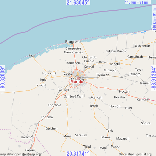
Mérida GPS coordinates[2]
20° 58' 31.332" North, 89° 37' 1.056" West
| Map corner | latitude | longitude |
|---|---|---|
| Upper-left | 21.63045°, | -90.32009° |
| Center: | 20.97537°, | -89.61696° |
| Lower-right: | 20.31741°, | -88.91384° |
| Map W x H: | 146×146 km | = 90.7×90.7mi |
| max Lat: | 32.7° ⇑23.9% North |
| Mérida: | 20.97537° |
| min Lat: | ⇓76.1% South 14.53588° |
| min Long | Mérida | max Long |
| -117.105° | -89.61696° | -86.73105° |
| W 98%⇐ | ⇒2% E |
Elevation
Elevation of Mérida is 14 m = 46 ft, and this is 1239.7 m = 4067 ft below average elevation for this country.
| Max E: |
3497 m = 11473 ft | 94.6% |
| Avg. | 1253.7 m = 4113 ft | |
| Mérida | 14 m = 46 ft | |
Min E: |
-1 m = -3 ft | 5.4% |
See also: Mérida elevation on elevation.city.
Geographical zone
Mérida is located in North Torrid zone (between Equator and Tropic of Cancer). Distance of this Northern Tropic circle is 273.7 km =170.1 mi to North.| Distance of | km | miles | from Mérida |
|---|---|---|---|
| North Pole | 7674.8 | 4768.9 | to North |
| Arctic Circle | 5068.9 | 3149.7 | to North |
| Tropic Cancer | 273.7 | 170.1 | to North |
| Equator | 2332.2 | 1449.2 | to South |


Nearby cities:
15 places around Mérida: (largest is in red/bold)
• Caucel
10 km =6.2 mi,  296°
296°
• Cholul
9.6 km =6 mi,  38°
38°
• Dzityá
10.6 km =6.6 mi,  323°
323°
• Itzincab Palomeque
10.7 km =6.6 mi,  232°
232°
• Kanasín
7.5 km =4.7 mi,  126°
126°
• Leona Vicario
7.5 km =4.7 mi,  167°
167°
• Opichen
7.1 km =4.4 mi,  246°
246°
• Santa Cruz Palomeque
11.2 km =7 mi,  199°
199°
• Sitpach
11.5 km =7.1 mi,  60°
60°
• Tahdzibichen
10.1 km =6.3 mi, 168°
• Teya
10.9 km =6.8 mi,  113°
113°
• Ticimul
12.6 km =7.8 mi,  213°
213°
• Tizcacal Opichen
10.7 km =6.6 mi, 251°
• Xcanatún
11.3 km =7 mi,  353°
353°
• Xmatkuíl
12.8 km =8 mi,  183°
183°
Sources, notices
• [Note1] Compared only with cities in Mexico existing in our database
• [Src1] Map data: © OpenStreetMap contributors (CC-BY-SA)
• [Src2] Other city data from geonames.org with taken over terms of usage.
• [Src3] Geographical zone / Annual Mean Temperature by Robert A. Rohde @ Wikipedia
