Chablekal geodata
Chablekal (Yucatán) is a populated place; located in Mexico in America/Merida (GMT-6) time zone. With population of 3,626 people, there are 2528 cities with bigger population in this country. Compared to other cities in Mexico, 77.8% of cities are located further ↓South; 98% of cities are located further ←West and 96.3% of cities have higher elevation than Chablekal. Note1


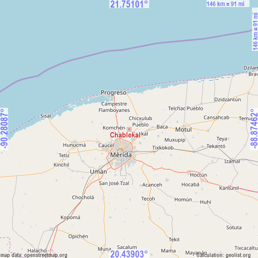
Chablekal GPS coordinates[2]
21° 5' 47.292" North, 89° 34' 39.864" West
| Map corner | latitude | longitude |
|---|---|---|
| Upper-left | 21.75101°, | -90.28087° |
| Center: | 21.09647°, | -89.57774° |
| Lower-right: | 20.43903°, | -88.87462° |
| Map W x H: | 145.9×145.9 km | = 90.7×90.7mi |
| max Lat: | 32.7° ⇑22.2% North |
| Chablekal: | 21.09647° |
| min Lat: | ⇓77.8% South 14.53588° |
| min Long | Chablekal | max Long |
| -117.105° | -89.57774° | -86.73105° |
| W 98%⇐ | ⇒2% E |
Elevation
Elevation of Chablekal is 11 m = 36 ft, and this is 1242.7 m = 4077 ft below average elevation for this country.
| Max E: |
3497 m = 11473 ft | 96.3% |
| Avg. | 1253.7 m = 4113 ft | |
| Chablekal | 11 m = 36 ft | |
Min E: |
-1 m = -3 ft | 3.7% |
See also: Mexico elevation on elevation.city.
Geographical zone
Chablekal is located in North Torrid zone (between Equator and Tropic of Cancer). Distance of this Northern Tropic circle is 260.2 km =161.7 mi to North.| Distance of | km | miles | from Chablekal |
|---|---|---|---|
| North Pole | 7661.4 | 4760.6 | to North |
| Arctic Circle | 5055.5 | 3141.3 | to North |
| Tropic Cancer | 260.2 | 161.7 | to North |
| Equator | 2345.7 | 1457.5 | to South |


Nearby cities:
15 places around Chablekal: (largest is in red/bold)
• Chicxulub Pueblo
7.8 km =4.8 mi,  55°
55°
• Cholul
6.3 km =3.9 mi,  161°
161°
• Conkal
6.5 km =4 mi,  112°
112°
• Cosgaya
13.3 km =8.3 mi,  271°
271°
• Dzityá
11.6 km =7.2 mi,  244°
244°
• Ixil
11.7 km =7.3 mi, 58°
• Komchén
8.8 km =5.5 mi,  275°
275°
• La Ceiba
5.4 km =3.4 mi,  263°
263°
• Mococha
13.1 km =8.1 mi,  85°
85°
• San Ignacio
10.7 km =6.6 mi,  311°
311°
• Sitpach
9.7 km =6 mi,  142°
142°
• Tamanché
8.1 km =5 mi, 305°
• Tekát
10.8 km =6.7 mi, 89°
• Xcanatún
5.9 km =3.7 mi,  247°
247°
• Xcunyá
5.5 km =3.4 mi,  317°
317°
Sources, notices
• [Note1] Compared only with cities in Mexico existing in our database
• [Src1] Map data: © OpenStreetMap contributors (CC-BY-SA)
• [Src2] Other city data from geonames.org with taken over terms of usage.
• [Src3] Geographical zone / Annual Mean Temperature by Robert A. Rohde @ Wikipedia
