Cholul geodata
Cholul (Yucatán) is a populated place; located in Mexico in America/Merida (GMT-6) time zone. With population of 5,880 people, there are 1583 cities with bigger population in this country. Compared to other cities in Mexico, 77.1% of cities are located further ↓South; 98% of cities are located further ←West and 95.7% of cities have higher elevation than Cholul. Note1


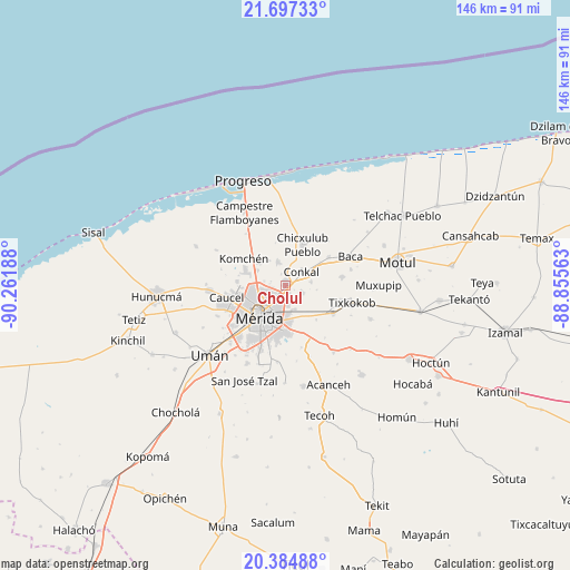
Cholul GPS coordinates[2]
21° 2' 33.18" North, 89° 33' 31.5" West
| Map corner | latitude | longitude |
|---|---|---|
| Upper-left | 21.69733°, | -90.26188° |
| Center: | 21.04255°, | -89.55875° |
| Lower-right: | 20.38488°, | -88.85563° |
| Map W x H: | 145.9×145.9 km | = 90.7×90.7mi |
| max Lat: | 32.7° ⇑22.9% North |
| Cholul: | 21.04255° |
| min Lat: | ⇓77.1% South 14.53588° |
| min Long | Cholul | max Long |
| -117.105° | -89.55875° | -86.73105° |
| W 98%⇐ | ⇒2% E |
Elevation
Elevation of Cholul is 12 m = 39 ft, and this is 1241.7 m = 4074 ft below average elevation for this country.
| Max E: |
3497 m = 11473 ft | 95.7% |
| Avg. | 1253.7 m = 4113 ft | |
| Cholul | 12 m = 39 ft | |
Min E: |
-1 m = -3 ft | 4.3% |
See also: Mexico elevation on elevation.city.
Geographical zone
Cholul is located in North Torrid zone (between Equator and Tropic of Cancer). Distance of this Northern Tropic circle is 266.2 km =165.4 mi to North.| Distance of | km | miles | from Cholul |
|---|---|---|---|
| North Pole | 7667.3 | 4764.2 | to North |
| Arctic Circle | 5061.5 | 3145.1 | to North |
| Tropic Cancer | 266.2 | 165.4 | to North |
| Equator | 2339.7 | 1453.8 | to South |


Nearby cities:
15 places around Cholul: (largest is in red/bold)
• Chablekal
6.3 km =3.9 mi,  341°
341°
• Chicxulub Pueblo
11.3 km =7 mi,  22°
22°
• Chochoh
10.9 km =6.8 mi,  119°
119°
• Conkal
5.3 km =3.3 mi,  49°
49°
• Dzityá
12.5 km =7.8 mi,  274°
274°
• Kanasín
12 km =7.5 mi,  179°
179°
• Komchén
12.7 km =7.9 mi,  302°
302°
• La Ceiba
9.1 km =5.7 mi,  306°
306°
• Mérida
9.6 km =6 mi,  218°
218°
• Oncan
11.7 km =7.3 mi,  138°
138°
• Sitpach
4.3 km =2.7 mi,  114°
114°
• Tekát
10.7 km =6.6 mi,  55°
55°
• Teya
12.4 km =7.7 mi,  161°
161°
• Xcanatún
8.3 km =5.2 mi, 297°
• Xcunyá
11.5 km =7.1 mi,  330°
330°
Sources, notices
• [Note1] Compared only with cities in Mexico existing in our database
• [Src1] Map data: © OpenStreetMap contributors (CC-BY-SA)
• [Src2] Other city data from geonames.org with taken over terms of usage.
• [Src3] Geographical zone / Annual Mean Temperature by Robert A. Rohde @ Wikipedia
