Xaltitla geodata
Xaltitla (Tlaxcala) is a populated place; located in Mexico in America/Mexico_City (GMT-6) time zone. With population of 564 people, there are 15153 cities with bigger population in this country. Compared to other cities in Mexico, 55.7% of cities are located further ↑North; 66.4% of cities are located further ←West and 93.9% of cities have lower elevation than Xaltitla. Note1


Xaltitla GPS coordinates[2]
19° 25' 21.576" North, 97° 46' 26.58" West
| Map corner | latitude | longitude |
|---|---|---|
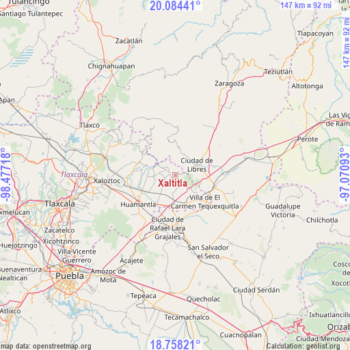
| Upper-left | 20.08441°, | -98.47718° |
| Center: | 19.42266°, | -97.77405° |
| Lower-right: | 18.75821°, | -97.07093° |
| Map W x H: | 147.5×147.5 km | = 91.7×91.7mi |
| max Lat: | 32.7° ⇑55.7% North |
| Xaltitla: | 19.42266° |
| min Lat: | ⇓44.3% South 14.53588° |
| min Long | Xaltitla | max Long |
| -117.105° | -97.77405° | -86.73105° |
| W 66.4%⇐ | ⇒33.6% E |
Elevation
Elevation of Xaltitla is 2571 m = 8435 ft, and this is 1317.3 m = 4322 ft above average elevation for this country.
| Max E: |
3497 m = 11473 ft | 6.1% |
| Xaltitla | 2571 m 8435 ft | |
| Avg. | 1253.7 m = 4113 ft | |
Min E: |
-1 m = -3 ft | 93.9% |
See also: Mexico elevation on elevation.city.
Geographical zone
Xaltitla is located in North Torrid zone (between Equator and Tropic of Cancer). Distance of this Northern Tropic circle is 446.3 km =277.3 mi to North.| Distance of | km | miles | from Xaltitla |
|---|---|---|---|
| North Pole | 7847.5 | 4876.2 | to North |
| Arctic Circle | 5241.6 | 3257 | to North |
| Tropic Cancer | 446.3 | 277.3 | to North |
| Equator | 2159.6 | 1341.9 | to South |


Nearby cities:
15 places around Xaltitla: (largest is in red/bold)
• Altzayanca
2.4 km =1.5 mi,  292°
292°
• Atlzayanca
2.4 km =1.5 mi, 292°
• Ayehualaco (San Martín)
7.3 km =4.5 mi,  76°
76°
• Colonia Ignacio Allende
7.4 km =4.6 mi,  188°
188°
• Concepción Hidalgo
5.5 km =3.4 mi,  240°
240°
• Cristalaco
9.9 km =6.2 mi,  310°
310°
• Felipe Carrillo Puerto
8.9 km =5.5 mi,  252°
252°
• Guerrero
9.1 km =5.7 mi, 82°
• La Cañada
9.5 km =5.9 mi,  26°
26°
• Nexnopala
2.9 km =1.8 mi,  203°
203°
• Ranchería de Pocitos
3.5 km =2.2 mi,  154°
154°
• San Carlos
9 km =5.6 mi, 78°
• San José Xicohténcatl
9.6 km =6 mi,  218°
218°
• Santa Cruz Pocitos
5 km =3.1 mi,  164°
164°
• Santa María las Cuevas
5.5 km =3.4 mi,  138°
138°
Sources, notices
• [Note1] Compared only with cities in Mexico existing in our database
• [Src1] Map data: © OpenStreetMap contributors (CC-BY-SA)
• [Src2] Other city data from geonames.org with taken over terms of usage.
• [Src3] Geographical zone / Annual Mean Temperature by Robert A. Rohde @ Wikipedia
