Altzayanca geodata
Altzayanca (Tlaxcala) is a seat of a second-order administrative division; located in Mexico in America/Mexico_City (GMT-6) time zone. With population of 3,353 people, there are 2708 cities with bigger population in this country. Compared to other cities in Mexico, 55.5% of cities are located further ↑North; 66.2% of cities are located further ←West and 95.3% of cities have lower elevation than Altzayanca. Note1


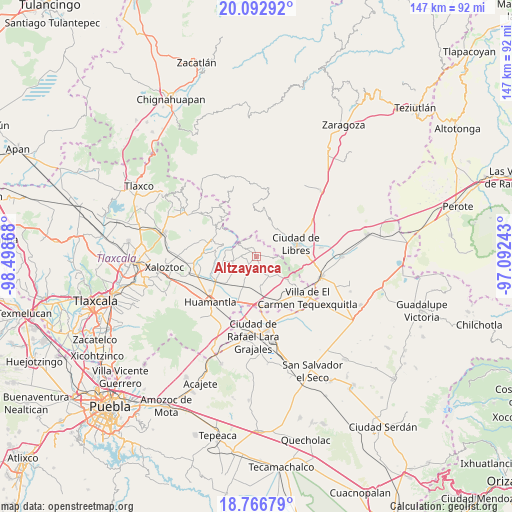
Altzayanca GPS coordinates[2]
19° 25' 52.356" North, 97° 47' 43.98" West
| Map corner | latitude | longitude |
|---|---|---|
| Upper-left | 20.09292°, | -98.49868° |
| Center: | 19.43121°, | -97.79555° |
| Lower-right: | 18.76679°, | -97.09243° |
| Map W x H: | 147.5×147.5 km | = 91.7×91.7mi |
| max Lat: | 32.7° ⇑55.5% North |
| Altzayanca: | 19.43121° |
| min Lat: | ⇓44.5% South 14.53588° |
| min Long | Altzayanca | max Long |
| -117.105° | -97.79555° | -86.73105° |
| W 66.2%⇐ | ⇒33.8% E |
Elevation
Elevation of Altzayanca is 2603 m = 8540 ft, and this is 1349.3 m = 4427 ft above average elevation for this country.
| Max E: |
3497 m = 11473 ft | 4.7% |
| Altzayanca | 2603 m 8540 ft | |
| Avg. | 1253.7 m = 4113 ft | |
Min E: |
-1 m = -3 ft | 95.3% |
See also: Mexico elevation on elevation.city.
Geographical zone
Altzayanca is located in North Torrid zone (between Equator and Tropic of Cancer). Distance of this Northern Tropic circle is 445.4 km =276.8 mi to North.| Distance of | km | miles | from Altzayanca |
|---|---|---|---|
| North Pole | 7846.5 | 4875.6 | to North |
| Arctic Circle | 5240.6 | 3256.4 | to North |
| Tropic Cancer | 445.4 | 276.8 | to North |
| Equator | 2160.5 | 1342.5 | to South |


Nearby cities:
15 places around Altzayanca: (largest is in red/bold)
• Atlzayanca
0 km =0 mi,  185°
185°
• Ayehualaco (San Martín)
9.4 km =5.8 mi,  85°
85°
• Colonia Ignacio Allende
8.4 km =5.2 mi,  171°
171°
• Concepción Hidalgo
4.5 km =2.8 mi,  214°
214°
• Cristalaco
7.6 km =4.7 mi,  315°
315°
• Cuatexmola (Xonacatitla)
8.6 km =5.3 mi,  336°
336°
• Felipe Carrillo Puerto
7.2 km =4.5 mi,  240°
240°
• La Caldera
10.9 km =6.8 mi,  314°
314°
• La Cañada
9.9 km =6.2 mi,  40°
40°
• Nexnopala
3.8 km =2.4 mi,  163°
163°
• Ranchería de Pocitos
5.6 km =3.5 mi,  137°
137°
• San José Xicohténcatl
9.3 km =5.8 mi,  203°
203°
• Santa Cruz Pocitos
6.8 km =4.2 mi,  148°
148°
• Santa María las Cuevas
7.8 km =4.8 mi,  130°
130°
• Xaltitla
2.4 km =1.5 mi,  112°
112°
Sources, notices
• [Note1] Compared only with cities in Mexico existing in our database
• [Src1] Map data: © OpenStreetMap contributors (CC-BY-SA)
• [Src2] Other city data from geonames.org with taken over terms of usage.
• [Src3] Geographical zone / Annual Mean Temperature by Robert A. Rohde @ Wikipedia
