Villaflores geodata
Villaflores (Chiapas) is a seat of a second-order administrative division; located in Mexico in America/Mexico_City (GMT-6) time zone. With population of 37,237 people, there are 277 cities with bigger population in this country. Compared to other cities in Mexico, 96.1% of cities are located further ↑North; 87.2% of cities are located further ←West and 67.2% of cities have higher elevation than Villaflores. Note1


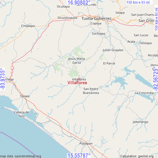
Villaflores GPS coordinates[2]
16° 14' 2.76" North, 93° 16' 13.332" West
| Map corner | latitude | longitude |
|---|---|---|
| Upper-left | 16.90802°, | -93.9735° |
| Center: | 16.2341°, | -93.27037° |
| Lower-right: | 15.55787°, | -92.56725° |
| Map W x H: | 150.1×150.1 km | = 93.3×93.3mi |
| max Lat: | 32.7° ⇑96.1% North |
| Villaflores: | 16.2341° |
| min Lat: | ⇓3.9% South 14.53588° |
| min Long | Villaflores | max Long |
| -117.105° | -93.27037° | -86.73105° |
| W 87.2%⇐ | ⇒12.8% E |
Elevation
Elevation of Villaflores is 571 m = 1873 ft, and this is 682.7 m = 2240 ft below average elevation for this country.
| Max E: |
3497 m = 11473 ft | 67.2% |
| Avg. | 1253.7 m = 4113 ft | |
| Villaflores | 571 m = 1873 ft | |
Min E: |
-1 m = -3 ft | 32.8% |
See also: Mexico elevation on elevation.city.
Geographical zone
Villaflores is located in North Torrid zone (between Equator and Tropic of Cancer). Distance of this Northern Tropic circle is 800.9 km =497.7 mi to North.| Distance of | km | miles | from Villaflores |
|---|---|---|---|
| North Pole | 8202 | 5096.5 | to North |
| Arctic Circle | 5596.1 | 3477.3 | to North |
| Tropic Cancer | 800.9 | 497.7 | to North |
| Equator | 1805.1 | 1121.6 | to South |


Nearby cities:
15 places around Villaflores: (largest is in red/bold)
• Calzada Larga
13.9 km =8.6 mi,  339°
339°
• Cuauhtémoc
11 km =6.8 mi,  35°
35°
• Dieciséis de Septiembre
12.4 km =7.7 mi,  55°
55°
• Doctor Domingo Chanona
20 km =12.4 mi,  308°
308°
• Emiliano Zapata
8 km =5 mi,  173°
173°
• Francisco Villa
7.4 km =4.6 mi,  252°
252°
• Ignacio Zaragoza
21.1 km =13.1 mi, 43°
• Jesús María Garza
18.2 km =11.3 mi,  352°
352°
• Joaquín Miguel Gutiérrez
18.2 km =11.3 mi,  326°
326°
• Monterrey
21.9 km =13.6 mi,  208°
208°
• Nueva Esperanza
3.1 km =1.9 mi,  221°
221°
• Revolución Mexicana
21.8 km =13.5 mi,  108°
108°
• Villa Corzo
5.5 km =3.4 mi,  178°
178°
• Villa Hidalgo
14.6 km =9.1 mi, 57°
• Úrsulo Galván
16.2 km =10.1 mi,  288°
288°
Sources, notices
• [Note1] Compared only with cities in Mexico existing in our database
• [Src1] Map data: © OpenStreetMap contributors (CC-BY-SA)
• [Src2] Other city data from geonames.org with taken over terms of usage.
• [Src3] Geographical zone / Annual Mean Temperature by Robert A. Rohde @ Wikipedia
