Villa Hidalgo geodata
Villa Hidalgo (Chiapas) is a populated place; located in Mexico in America/Mexico_City (GMT-6) time zone. With population of 2,502 people, there are 3531 cities with bigger population in this country. Compared to other cities in Mexico, 95.6% of cities are located further ↑North; 87.8% of cities are located further ←West and 67.8% of cities have higher elevation than Villa Hidalgo. Note1


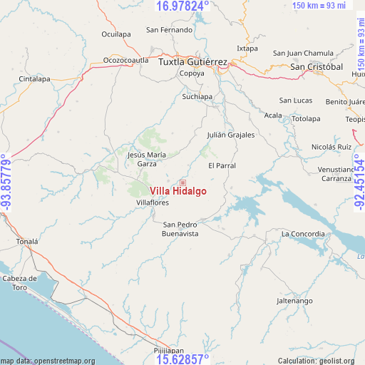
Villa Hidalgo GPS coordinates[2]
16° 18' 16.452" North, 93° 9' 16.776" West
| Map corner | latitude | longitude |
|---|---|---|
| Upper-left | 16.97824°, | -93.85779° |
| Center: | 16.30457°, | -93.15466° |
| Lower-right: | 15.62857°, | -92.45154° |
| Map W x H: | 150.1×150.1 km | = 93.3×93.3mi |
| max Lat: | 32.7° ⇑95.6% North |
| Villa Hidalgo: | 16.30457° |
| min Lat: | ⇓4.4% South 14.53588° |
| min Long | Villa Hidalgo | max Long |
| -117.105° | -93.15466° | -86.73105° |
| W 87.8%⇐ | ⇒12.2% E |
Elevation
Elevation of Villa Hidalgo is 537 m = 1762 ft, and this is 716.7 m = 2351 ft below average elevation for this country.
| Max E: |
3497 m = 11473 ft | 67.8% |
| Avg. | 1253.7 m = 4113 ft | |
| Villa Hidalgo | 537 m = 1762 ft | |
Min E: |
-1 m = -3 ft | 32.2% |
See also: Mexico elevation on elevation.city.
Geographical zone
Villa Hidalgo is located in North Torrid zone (between Equator and Tropic of Cancer). Distance of this Northern Tropic circle is 793 km =492.7 mi to North.| Distance of | km | miles | from Villa Hidalgo |
|---|---|---|---|
| North Pole | 8194.2 | 5091.6 | to North |
| Arctic Circle | 5588.3 | 3472.4 | to North |
| Tropic Cancer | 793 | 492.7 | to North |
| Equator | 1812.9 | 1126.5 | to South |


Nearby cities:
15 places around Villa Hidalgo: (largest is in red/bold)
• Calzada Larga
17.9 km =11.1 mi,  286°
286°
• Cuauhtémoc
6.1 km =3.8 mi,  280°
280°
• Dieciséis de Septiembre
2.3 km =1.4 mi,  249°
249°
• El Parral
17.5 km =10.9 mi,  65°
65°
• El Portillo
20.4 km =12.7 mi,  326°
326°
• Emiliano Zapata
19.5 km =12.1 mi,  215°
215°
• Ignacio Zaragoza
7.8 km =4.8 mi,  16°
16°
• Jericó
20.2 km =12.6 mi,  95°
95°
• Jesús María Garza
18 km =11.2 mi,  304°
304°
• Nueva Esperanza
17.6 km =10.9 mi,  234°
234°
• Palenque de los Pinos
20.6 km =12.8 mi, 15°
• Revolución Mexicana
17 km =10.6 mi,  150°
150°
• Roblada Grande
21 km =13 mi,  348°
348°
• Villa Corzo
18 km =11.2 mi, 222°
• Villaflores
14.6 km =9.1 mi,  237°
237°
Sources, notices
• [Note1] Compared only with cities in Mexico existing in our database
• [Src1] Map data: © OpenStreetMap contributors (CC-BY-SA)
• [Src2] Other city data from geonames.org with taken over terms of usage.
• [Src3] Geographical zone / Annual Mean Temperature by Robert A. Rohde @ Wikipedia
