Monterrey geodata
Monterrey (Chiapas) is a populated place; located in Mexico in America/Mexico_City (GMT-6) time zone. With population of 1,086 people, there are 8018 cities with bigger population in this country. Compared to other cities in Mexico, 97.1% of cities are located further ↑North; 86.9% of cities are located further ←West and 65% of cities have higher elevation than Monterrey. Note1


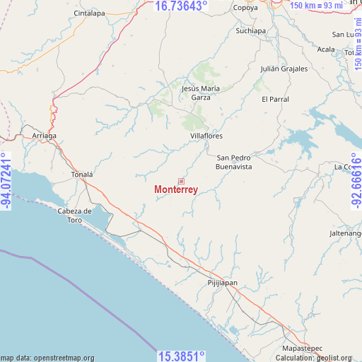
Monterrey GPS coordinates[2]
16° 3' 42.876" North, 93° 22' 9.408" West
| Map corner | latitude | longitude |
|---|---|---|
| Upper-left | 16.73643°, | -94.07241° |
| Center: | 16.06191°, | -93.36928° |
| Lower-right: | 15.3851°, | -92.66616° |
| Map W x H: | 150.3×150.3 km | = 93.4×93.4mi |
| max Lat: | 32.7° ⇑97.1% North |
| Monterrey: | 16.06191° |
| min Lat: | ⇓2.9% South 14.53588° |
| min Long | Monterrey | max Long |
| -117.105° | -93.36928° | -86.73105° |
| W 86.9%⇐ | ⇒13.1% E |
Elevation
Elevation of Monterrey is 686 m = 2251 ft, and this is 567.7 m = 1863 ft below average elevation for this country.
| Max E: |
3497 m = 11473 ft | 65% |
| Avg. | 1253.7 m = 4113 ft | |
| Monterrey | 686 m = 2251 ft | |
Min E: |
-1 m = -3 ft | 35% |
See also: Mexico elevation on elevation.city.
Geographical zone
Monterrey is located in North Torrid zone (between Equator and Tropic of Cancer). Distance of this Northern Tropic circle is 820 km =509.5 mi to North.| Distance of | km | miles | from Monterrey |
|---|---|---|---|
| North Pole | 8221.1 | 5108.4 | to North |
| Arctic Circle | 5615.3 | 3489.2 | to North |
| Tropic Cancer | 820 | 509.5 | to North |
| Equator | 1785.9 | 1109.7 | to South |


Nearby cities:
15 places around Monterrey: (largest is in red/bold)
• Calzada Larga
32.7 km =20.3 mi,  10°
10°
• Cuauhtémoc
32.8 km =20.4 mi,  31°
31°
• Dieciséis de Septiembre
33.4 km =20.8 mi,  38°
38°
• Doctor Domingo Chanona
32 km =19.9 mi,  350°
350°
• Emiliano Zapata
16 km =9.9 mi,  45°
45°
• Francisco Villa
17.3 km =10.7 mi, 11°
• La Polka
33.6 km =20.9 mi,  249°
249°
• Nueva Esperanza
18.8 km =11.7 mi, 26°
• Revolución Mexicana
33.6 km =20.9 mi,  68°
68°
• San Pedro Buenavista
27.1 km =16.8 mi,  84°
84°
• Tamaulipas
32.5 km =20.2 mi,  187°
187°
• Tres Picos
26.3 km =16.3 mi,  220°
220°
• Villa Corzo
17.4 km =10.8 mi, 38°
• Villaflores
21.9 km =13.6 mi, 28°
• Úrsulo Galván
24.7 km =15.3 mi, 348°
Sources, notices
• [Note1] Compared only with cities in Mexico existing in our database
• [Src1] Map data: © OpenStreetMap contributors (CC-BY-SA)
• [Src2] Other city data from geonames.org with taken over terms of usage.
• [Src3] Geographical zone / Annual Mean Temperature by Robert A. Rohde @ Wikipedia
