Nueva Esperanza geodata
Nueva Esperanza (Chiapas) is a populated place; located in Mexico in America/Mexico_City (GMT-6) time zone. With population of 613 people, there are 14065 cities with bigger population in this country. Compared to other cities in Mexico, 96.2% of cities are located further ↑North; 87.2% of cities are located further ←West and 67.1% of cities have higher elevation than Nueva Esperanza. Note1


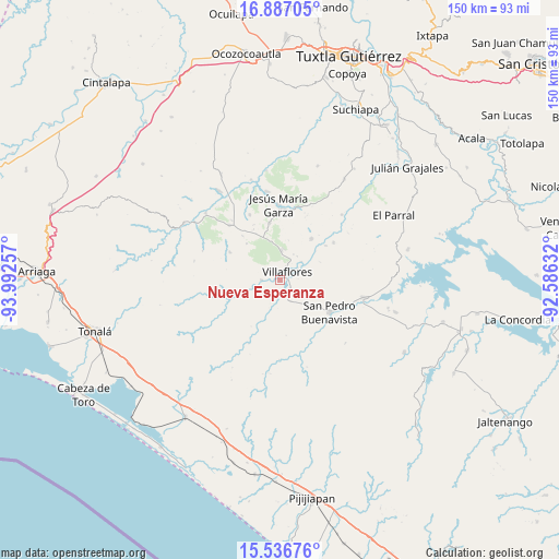
Nueva Esperanza GPS coordinates[2]
16° 12' 47.016" North, 93° 17' 21.984" West
| Map corner | latitude | longitude |
|---|---|---|
| Upper-left | 16.88705°, | -93.99257° |
| Center: | 16.21306°, | -93.28944° |
| Lower-right: | 15.53676°, | -92.58632° |
| Map W x H: | 150.1×150.1 km | = 93.3×93.3mi |
| max Lat: | 32.7° ⇑96.2% North |
| Nueva Esperanza: | 16.21306° |
| min Lat: | ⇓3.8% South 14.53588° |
| min Long | Nueva Esperanza | max Long |
| -117.105° | -93.28944° | -86.73105° |
| W 87.2%⇐ | ⇒12.8% E |
Elevation
Elevation of Nueva Esperanza is 581 m = 1906 ft, and this is 672.7 m = 2207 ft below average elevation for this country.
| Max E: |
3497 m = 11473 ft | 67.1% |
| Avg. | 1253.7 m = 4113 ft | |
| Nueva Esperanza | 581 m = 1906 ft | |
Min E: |
-1 m = -3 ft | 32.9% |
See also: Mexico elevation on elevation.city.
Geographical zone
Nueva Esperanza is located in North Torrid zone (between Equator and Tropic of Cancer). Distance of this Northern Tropic circle is 803.2 km =499.1 mi to North.| Distance of | km | miles | from Nueva Esperanza |
|---|---|---|---|
| North Pole | 8204.3 | 5097.9 | to North |
| Arctic Circle | 5598.5 | 3478.7 | to North |
| Tropic Cancer | 803.2 | 499.1 | to North |
| Equator | 1802.7 | 1120.1 | to South |


Nearby cities:
15 places around Nueva Esperanza: (largest is in red/bold)
• Calzada Larga
15.6 km =9.7 mi,  349°
349°
• Cuauhtémoc
14.1 km =8.8 mi,  36°
36°
• Dieciséis de Septiembre
15.4 km =9.6 mi,  52°
52°
• Doctor Domingo Chanona
20.1 km =12.5 mi,  317°
317°
• Emiliano Zapata
6.4 km =4 mi,  152°
152°
• Francisco Villa
5.1 km =3.2 mi,  271°
271°
• Jesús María Garza
20.4 km =12.7 mi,  358°
358°
• Joaquín Miguel Gutiérrez
19.2 km =11.9 mi,  335°
335°
• Monterrey
18.8 km =11.7 mi,  206°
206°
• Revolución Mexicana
23.2 km =14.4 mi,  101°
101°
• San Pedro Buenavista
23.4 km =14.5 mi,  128°
128°
• Villa Corzo
3.8 km =2.4 mi,  144°
144°
• Villa Hidalgo
17.6 km =10.9 mi, 54°
• Villaflores
3.1 km =1.9 mi, 41°
• Úrsulo Galván
15.3 km =9.5 mi,  298°
298°
Sources, notices
• [Note1] Compared only with cities in Mexico existing in our database
• [Src1] Map data: © OpenStreetMap contributors (CC-BY-SA)
• [Src2] Other city data from geonames.org with taken over terms of usage.
• [Src3] Geographical zone / Annual Mean Temperature by Robert A. Rohde @ Wikipedia
