Revolución Mexicana geodata
Revolución Mexicana (Chiapas) is a populated place; located in Mexico in America/Mexico_City (GMT-6) time zone. With population of 7,989 people, there are 1182 cities with bigger population in this country. Compared to other cities in Mexico, 96.5% of cities are located further ↑North; 88.2% of cities are located further ←West and 67.6% of cities have higher elevation than Revolución Mexicana. Note1


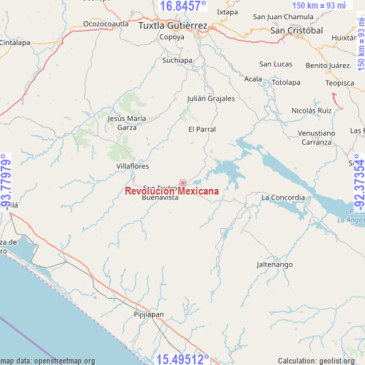
Revolución Mexicana GPS coordinates[2]
16° 10' 17.616" North, 93° 4' 35.976" West
| Map corner | latitude | longitude |
|---|---|---|
| Upper-left | 16.8457°, | -93.77979° |
| Center: | 16.17156°, | -93.07666° |
| Lower-right: | 15.49512°, | -92.37354° |
| Map W x H: | 150.2×150.2 km | = 93.3×93.3mi |
| max Lat: | 32.7° ⇑96.5% North |
| Revolución Mexicana: | 16.17156° |
| min Lat: | ⇓3.5% South 14.53588° |
| min Long | Revolución Mex | max Long |
| -117.105° | -93.07666° | -86.73105° |
| W 88.2%⇐ | ⇒11.8% E |
Elevation
Elevation of Revolución Mexicana is 550 m = 1804 ft, and this is 703.7 m = 2309 ft below average elevation for this country.
| Max E: |
3497 m = 11473 ft | 67.6% |
| Avg. | 1253.7 m = 4113 ft | |
| Revolución Mexicana | 550 m = 1804 ft | |
Min E: |
-1 m = -3 ft | 32.4% |
See also: Mexico elevation on elevation.city.
Geographical zone
Revolución Mexicana is located in North Torrid zone (between Equator and Tropic of Cancer). Distance of this Northern Tropic circle is 807.8 km =501.9 mi to North.| Distance of | km | miles | from Revolución Mexicana |
|---|---|---|---|
| North Pole | 8209 | 5100.8 | to North |
| Arctic Circle | 5603.1 | 3481.6 | to North |
| Tropic Cancer | 807.8 | 501.9 | to North |
| Equator | 1798.1 | 1117.3 | to South |


Nearby cities:
15 places around Revolución Mexicana: (largest is in red/bold)
• Cuauhtémoc
21.4 km =13.3 mi,  318°
318°
• Diamante de Echeverría
22.1 km =13.7 mi,  107°
107°
• Dieciséis de Septiembre
17.5 km =10.9 mi, 323°
• Embarcadero de Jericó (El Siglo)
15.4 km =9.6 mi,  77°
77°
• Emiliano Zapata
19.8 km =12.3 mi,  267°
267°
• Ignacio Zaragoza
23.1 km =14.4 mi,  344°
344°
• Jericó
17.4 km =10.8 mi,  42°
42°
• Loma Bonita
11.9 km =7.4 mi,  71°
71°
• Manuel Ávila Camacho
7 km =4.3 mi, 113°
• Nuevo Vicente Guerrero
18.3 km =11.4 mi,  143°
143°
• San Pedro Buenavista
10.7 km =6.6 mi,  203°
203°
• Santiago
7.5 km =4.7 mi,  119°
119°
• Villa Corzo
20.6 km =12.8 mi, 274°
• Villa Hidalgo
17 km =10.6 mi,  330°
330°
• Villaflores
21.8 km =13.5 mi,  288°
288°
Sources, notices
• [Note1] Compared only with cities in Mexico existing in our database
• [Src1] Map data: © OpenStreetMap contributors (CC-BY-SA)
• [Src2] Other city data from geonames.org with taken over terms of usage.
• [Src3] Geographical zone / Annual Mean Temperature by Robert A. Rohde @ Wikipedia
