Baca geodata
Baca (Yucatán) is a populated place; located in Mexico in America/Merida (GMT-6) time zone. With population of 4,553 people, there are 2021 cities with bigger population in this country. Compared to other cities in Mexico, 78% of cities are located further ↓South; 98.3% of cities are located further ←West and 97% of cities have higher elevation than Baca. Note1


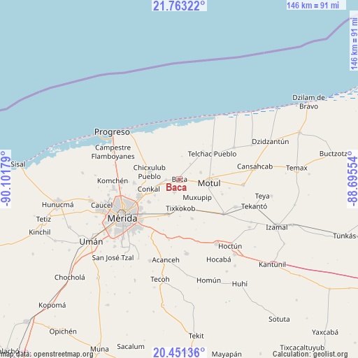
Baca GPS coordinates[2]
21° 6' 31.464" North, 89° 23' 55.176" West
| Map corner | latitude | longitude |
|---|---|---|
| Upper-left | 21.76322°, | -90.10179° |
| Center: | 21.10874°, | -89.39866° |
| Lower-right: | 20.45136°, | -88.69554° |
| Map W x H: | 145.9×145.9 km | = 90.7×90.7mi |
| max Lat: | 32.7° ⇑22% North |
| Baca: | 21.10874° |
| min Lat: | ⇓78% South 14.53588° |
| min Long | Baca | max Long |
| -117.105° | -89.39866° | -86.73105° |
| W 98.3%⇐ | ⇒1.7% E |
Elevation
Elevation of Baca is 10 m = 33 ft, and this is 1243.7 m = 4080 ft below average elevation for this country.
| Max E: |
3497 m = 11473 ft | 97% |
| Avg. | 1253.7 m = 4113 ft | |
| Baca | 10 m = 33 ft | |
Min E: |
-1 m = -3 ft | 3% |
See also: Mexico elevation on elevation.city.
Geographical zone
Baca is located in North Torrid zone (between Equator and Tropic of Cancer). Distance of this Northern Tropic circle is 258.8 km =160.8 mi to North.| Distance of | km | miles | from Baca |
|---|---|---|---|
| North Pole | 7660 | 4759.7 | to North |
| Arctic Circle | 5054.1 | 3140.5 | to North |
| Tropic Cancer | 258.8 | 160.8 | to North |
| Equator | 2347.1 | 1458.4 | to South |


Nearby cities:
15 places around Baca: (largest is in red/bold)
• Chicxulub Pueblo
12.6 km =7.8 mi,  284°
284°
• Conkal
13.2 km =8.2 mi,  252°
252°
• Ixil
9.9 km =6.2 mi,  299°
299°
• Kini
9 km =5.6 mi,  70°
70°
• Mococha
5.6 km =3.5 mi,  267°
267°
• Motul
12.1 km =7.5 mi,  96°
96°
• Muxupip
10.3 km =6.4 mi,  135°
135°
• Nolo
11.3 km =7 mi,  192°
192°
• Sacapuc
7.7 km =4.8 mi,  35°
35°
• Tekát
7.9 km =4.9 mi,  260°
260°
• Timul
9.4 km =5.8 mi,  5°
5°
• Tixkokob
11.9 km =7.4 mi,  178°
178°
• Tixkunchell
3.2 km =2 mi, 178°
• Uci
13.7 km =8.5 mi,  81°
81°
• Yaxkukul
5.7 km =3.5 mi,  202°
202°
Sources, notices
• [Note1] Compared only with cities in Mexico existing in our database
• [Src1] Map data: © OpenStreetMap contributors (CC-BY-SA)
• [Src2] Other city data from geonames.org with taken over terms of usage.
• [Src3] Geographical zone / Annual Mean Temperature by Robert A. Rohde @ Wikipedia
