San Javier geodata
San Javier (Querétaro) is a populated place; located in Mexico in America/Mexico_City (GMT-6) time zone. With population of 1,871 people, there are 4641 cities with bigger population in this country. Compared to other cities in Mexico, 72.6% of cities are located further ↓South; 60.4% of cities are located further →East and 82.7% of cities have lower elevation than San Javier. Note1


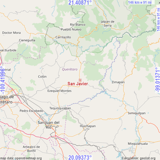
San Javier GPS coordinates[2]
20° 45' 9.54" North, 99° 43' 0.588" West
| Map corner | latitude | longitude |
|---|---|---|
| Upper-left | 21.40871°, | -100.41996° |
| Center: | 20.75265°, | -99.71683° |
| Lower-right: | 20.09373°, | -99.01371° |
| Map W x H: | 146.2×146.2 km | = 90.8×90.8mi |
| max Lat: | 32.7° ⇑27.4% North |
| San Javier: | 20.75265° |
| min Lat: | ⇓72.6% South 14.53588° |
| min Long | San Javier | max Long |
| -117.105° | -99.71683° | -86.73105° |
| W 39.6%⇐ | ⇒60.4% E |
Elevation
Elevation of San Javier is 2207 m = 7241 ft, and this is 953.3 m = 3128 ft above average elevation for this country.
| Max E: |
3497 m = 11473 ft | 17.3% |
| San Javier | 2207 m 7241 ft | |
| Avg. | 1253.7 m = 4113 ft | |
Min E: |
-1 m = -3 ft | 82.7% |
See also: Mexico elevation on elevation.city.
Geographical zone
San Javier is located in North Torrid zone (between Equator and Tropic of Cancer). Distance of this Northern Tropic circle is 298.4 km =185.4 mi to North.| Distance of | km | miles | from San Javier |
|---|---|---|---|
| North Pole | 7699.6 | 4784.3 | to North |
| Arctic Circle | 5093.7 | 3165.1 | to North |
| Tropic Cancer | 298.4 | 185.4 | to North |
| Equator | 2307.5 | 1433.8 | to South |


Nearby cities:
15 places around San Javier: (largest is in red/bold)
• Boyé
8.3 km =5.2 mi,  196°
196°
• Cadereyta
12 km =7.5 mi,  239°
239°
• Cerro Prieto
9.2 km =5.7 mi,  125°
125°
• El Palmar
6.7 km =4.2 mi,  170°
170°
• El Rincón
7.2 km =4.5 mi,  259°
259°
• Los Juárez
14.6 km =9.1 mi,  28°
28°
• Puerto de Chiquihuite
13.6 km =8.5 mi, 244°
• Puerto del Salitre
4.3 km =2.7 mi,  140°
140°
• San Martín Florida
11.3 km =7 mi,  272°
272°
• Santa Bárbara
8.7 km =5.4 mi, 266°
• Sombrerete
6.6 km =4.1 mi,  50°
50°
• Villa Guerrero
7.7 km =4.8 mi,  216°
216°
• Villa Nueva
14.1 km =8.8 mi,  229°
229°
• Vizarrón
8.8 km =5.5 mi,  357°
357°
• Zituní
12.5 km =7.8 mi,  249°
249°
Sources, notices
• [Note1] Compared only with cities in Mexico existing in our database
• [Src1] Map data: © OpenStreetMap contributors (CC-BY-SA)
• [Src2] Other city data from geonames.org with taken over terms of usage.
• [Src3] Geographical zone / Annual Mean Temperature by Robert A. Rohde @ Wikipedia
