Sombrerete geodata
Sombrerete (Querétaro) is a populated place; located in Mexico in America/Mexico_City (GMT-6) time zone. With population of 594 people, there are 14476 cities with bigger population in this country. Compared to other cities in Mexico, 73.1% of cities are located further ↓South; 59.8% of cities are located further →East and 94.5% of cities have lower elevation than Sombrerete. Note1


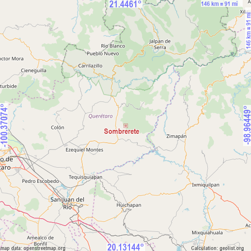
Sombrerete GPS coordinates[2]
20° 47' 24.72" North, 99° 40' 3.396" West
| Map corner | latitude | longitude |
|---|---|---|
| Upper-left | 21.4461°, | -100.37074° |
| Center: | 20.7902°, | -99.66761° |
| Lower-right: | 20.13144°, | -98.96449° |
| Map W x H: | 146.2×146.2 km | = 90.8×90.8mi |
| max Lat: | 32.7° ⇑26.9% North |
| Sombrerete: | 20.7902° |
| min Lat: | ⇓73.1% South 14.53588° |
| min Long | Sombrerete | max Long |
| -117.105° | -99.66761° | -86.73105° |
| W 40.2%⇐ | ⇒59.8% E |
Elevation
Elevation of Sombrerete is 2584 m = 8478 ft, and this is 1330.3 m = 4365 ft above average elevation for this country.
| Max E: |
3497 m = 11473 ft | 5.5% |
| Sombrerete | 2584 m 8478 ft | |
| Avg. | 1253.7 m = 4113 ft | |
Min E: |
-1 m = -3 ft | 94.5% |
See also: Mexico elevation on elevation.city.
Geographical zone
Sombrerete is located in North Torrid zone (between Equator and Tropic of Cancer). Distance of this Northern Tropic circle is 294.3 km =182.9 mi to North.| Distance of | km | miles | from Sombrerete |
|---|---|---|---|
| North Pole | 7695.4 | 4781.7 | to North |
| Arctic Circle | 5089.5 | 3162.5 | to North |
| Tropic Cancer | 294.3 | 182.9 | to North |
| Equator | 2311.7 | 1436.4 | to South |


Nearby cities:
15 places around Sombrerete: (largest is in red/bold)
• Bella Vista del Río
15 km =9.3 mi,  138°
138°
• Boyé
14.3 km =8.9 mi,  211°
211°
• Cerro Prieto
9.8 km =6.1 mi,  165°
165°
• El Palmar
11.5 km =7.1 mi,  200°
200°
• El Rincón
13.3 km =8.3 mi,  245°
245°
• Higuerillas
17.3 km =10.7 mi,  324°
324°
• Los Juárez
8.9 km =5.5 mi,  11°
11°
• Maconí
14.8 km =9.2 mi,  69°
69°
• Puerto del Salitre
7.9 km =4.9 mi, 197°
• San Javier
6.6 km =4.1 mi,  230°
230°
• San Joaquín
17.5 km =10.9 mi,  37°
37°
• San Martín Florida
16.8 km =10.4 mi,  257°
257°
• Santa Bárbara
14.6 km =9.1 mi, 250°
• Villa Guerrero
14.2 km =8.8 mi,  223°
223°
• Vizarrón
7.2 km =4.5 mi,  310°
310°
Sources, notices
• [Note1] Compared only with cities in Mexico existing in our database
• [Src1] Map data: © OpenStreetMap contributors (CC-BY-SA)
• [Src2] Other city data from geonames.org with taken over terms of usage.
• [Src3] Geographical zone / Annual Mean Temperature by Robert A. Rohde @ Wikipedia
