El Palmar geodata
El Palmar (Querétaro) is a populated place; located in Mexico in America/Mexico_City (GMT-6) time zone. With population of 2,884 people, there are 3083 cities with bigger population in this country. Compared to other cities in Mexico, 71.5% of cities are located further ↓South; 60.3% of cities are located further →East and 74.8% of cities have lower elevation than El Palmar. Note1


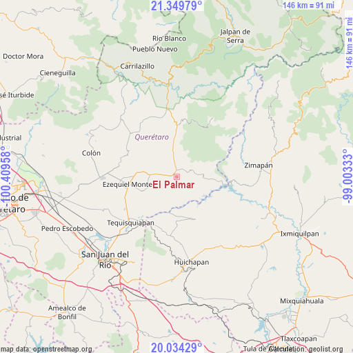
El Palmar GPS coordinates[2]
20° 41' 36.492" North, 99° 42' 23.22" West
| Map corner | latitude | longitude |
|---|---|---|
| Upper-left | 21.34979°, | -100.40958° |
| Center: | 20.69347°, | -99.70645° |
| Lower-right: | 20.03429°, | -99.00333° |
| Map W x H: | 146.3×146.3 km | = 90.9×90.9mi |
| max Lat: | 32.7° ⇑28.5% North |
| El Palmar: | 20.69347° |
| min Lat: | ⇓71.5% South 14.53588° |
| min Long | El Palmar | max Long |
| -117.105° | -99.70645° | -86.73105° |
| W 39.7%⇐ | ⇒60.3% E |
Elevation
Elevation of El Palmar is 2027 m = 6650 ft, and this is 773.3 m = 2537 ft above average elevation for this country.
| Max E: |
3497 m = 11473 ft | 25.2% |
| El Palmar | 2027 m 6650 ft | |
| Avg. | 1253.7 m = 4113 ft | |
Min E: |
-1 m = -3 ft | 74.8% |
See also: Mexico elevation on elevation.city.
Geographical zone
El Palmar is located in North Torrid zone (between Equator and Tropic of Cancer). Distance of this Northern Tropic circle is 305 km =189.5 mi to North.| Distance of | km | miles | from El Palmar |
|---|---|---|---|
| North Pole | 7706.2 | 4788.4 | to North |
| Arctic Circle | 5100.3 | 3169.2 | to North |
| Tropic Cancer | 305 | 189.5 | to North |
| Equator | 2300.9 | 1429.7 | to South |


Nearby cities:
15 places around El Palmar: (largest is in red/bold)
• Boyecito
12 km =7.5 mi,  168°
168°
• Boyé
3.7 km =2.3 mi,  247°
247°
• Cadereyta
11.4 km =7.1 mi,  271°
271°
• Cerro Prieto
6.6 km =4.1 mi,  78°
78°
• El Rincón
9.7 km =6 mi,  303°
303°
• Pathé
10.4 km =6.5 mi,  177°
177°
• Portezuelo
11.5 km =7.1 mi,  197°
197°
• Puerto del Salitre
3.7 km =2.3 mi,  27°
27°
• San Javier
6.7 km =4.2 mi,  350°
350°
• Santa Bárbara
11.4 km =7.1 mi, 301°
• Sombrerete
11.5 km =7.1 mi,  20°
20°
• Uxdejhé
13.2 km =8.2 mi,  161°
161°
• Villa Guerrero
5.7 km =3.5 mi, 274°
• Villa Nueva
12.1 km =7.5 mi,  257°
257°
• Zituní
13 km =8.1 mi,  279°
279°
Sources, notices
• [Note1] Compared only with cities in Mexico existing in our database
• [Src1] Map data: © OpenStreetMap contributors (CC-BY-SA)
• [Src2] Other city data from geonames.org with taken over terms of usage.
• [Src3] Geographical zone / Annual Mean Temperature by Robert A. Rohde @ Wikipedia
