Tonalapa geodata
Tonalapa (Puebla) is a populated place; located in Mexico in America/Mexico_City (GMT-6) time zone. With population of 573 people, there are 14945 cities with bigger population in this country. Compared to other cities in Mexico, 53.1% of cities are located further ↓South; 65.1% of cities are located further ←West and 69.7% of cities have lower elevation than Tonalapa. Note1


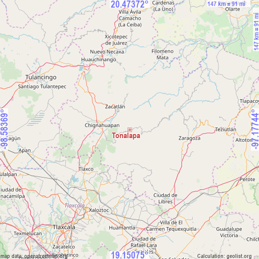
Tonalapa GPS coordinates[2]
19° 48' 48.996" North, 97° 52' 50.016" West
| Map corner | latitude | longitude |
|---|---|---|
| Upper-left | 20.47372°, | -98.58369° |
| Center: | 19.81361°, | -97.88056° |
| Lower-right: | 19.15075°, | -97.17744° |
| Map W x H: | 147.1×147.1 km | = 91.4×91.4mi |
| max Lat: | 32.7° ⇑46.9% North |
| Tonalapa: | 19.81361° |
| min Lat: | ⇓53.1% South 14.53588° |
| min Long | Tonalapa | max Long |
| -117.105° | -97.88056° | -86.73105° |
| W 65.1%⇐ | ⇒34.9% E |
Elevation
Elevation of Tonalapa is 1919 m = 6296 ft, and this is 665.3 m = 2183 ft above average elevation for this country.
| Max E: |
3497 m = 11473 ft | 30.3% |
| Tonalapa | 1919 m 6296 ft | |
| Avg. | 1253.7 m = 4113 ft | |
Min E: |
-1 m = -3 ft | 69.7% |
See also: Mexico elevation on elevation.city.
Geographical zone
Tonalapa is located in North Torrid zone (between Equator and Tropic of Cancer). Distance of this Northern Tropic circle is 402.9 km =250.4 mi to North.| Distance of | km | miles | from Tonalapa |
|---|---|---|---|
| North Pole | 7804 | 4849.2 | to North |
| Arctic Circle | 5198.1 | 3229.9 | to North |
| Tropic Cancer | 402.9 | 250.4 | to North |
| Equator | 2203.1 | 1368.9 | to South |


Nearby cities:
15 places around Tonalapa: (largest is in red/bold)
• Aquixtla
6.1 km =3.8 mi,  251°
251°
• Atexcac
4.5 km =2.8 mi,  269°
269°
• Benito Juárez
9.4 km =5.8 mi,  88°
88°
• Chichicaxtla
12 km =7.5 mi,  231°
231°
• Cuapancingo
3.2 km =2 mi,  67°
67°
• Cuautieco
5.6 km =3.5 mi, 231°
• El Terrero
7.7 km =4.8 mi, 247°
• Hueytentan
9.5 km =5.9 mi,  38°
38°
• Ixtolco de Morelos
12.2 km =7.6 mi,  32°
32°
• San Miguel Tenango
12 km =7.5 mi,  331°
331°
• Tetela de Ocampo
7.7 km =4.8 mi, 86°
• Tomatlán
13.2 km =8.2 mi,  312°
312°
• Xaltatempa de Lucas
8 km =5 mi, 26°
• Xonotla
12.4 km =7.7 mi,  349°
349°
• Zoyatitla
6.6 km =4.1 mi,  80°
80°
Sources, notices
• [Note1] Compared only with cities in Mexico existing in our database
• [Src1] Map data: © OpenStreetMap contributors (CC-BY-SA)
• [Src2] Other city data from geonames.org with taken over terms of usage.
• [Src3] Geographical zone / Annual Mean Temperature by Robert A. Rohde @ Wikipedia
