Aquixtla geodata
Aquixtla (Puebla) is a seat of a second-order administrative division; located in Mexico in America/Mexico_City (GMT-6) time zone. With population of 901 people, there are 9681 cities with bigger population in this country. Compared to other cities in Mexico, 52.7% of cities are located further ↓South; 64.4% of cities are located further ←West and 82.4% of cities have lower elevation than Aquixtla. Note1


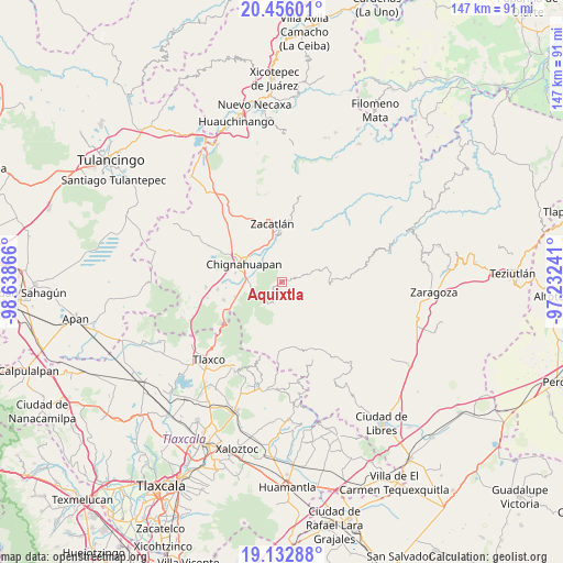
Aquixtla GPS coordinates[2]
19° 47' 44.952" North, 97° 56' 7.908" West
| Map corner | latitude | longitude |
|---|---|---|
| Upper-left | 20.45601°, | -98.63866° |
| Center: | 19.79582°, | -97.93553° |
| Lower-right: | 19.13288°, | -97.23241° |
| Map W x H: | 147.1×147.1 km | = 91.4×91.4mi |
| max Lat: | 32.7° ⇑47.3% North |
| Aquixtla: | 19.79582° |
| min Lat: | ⇓52.7% South 14.53588° |
| min Long | Aquixtla | max Long |
| -117.105° | -97.93553° | -86.73105° |
| W 64.4%⇐ | ⇒35.6% E |
Elevation
Elevation of Aquixtla is 2198 m = 7211 ft, and this is 944.3 m = 3098 ft above average elevation for this country.
| Max E: |
3497 m = 11473 ft | 17.6% |
| Aquixtla | 2198 m 7211 ft | |
| Avg. | 1253.7 m = 4113 ft | |
Min E: |
-1 m = -3 ft | 82.4% |
See also: Mexico elevation on elevation.city.
Geographical zone
Aquixtla is located in North Torrid zone (between Equator and Tropic of Cancer). Distance of this Northern Tropic circle is 404.8 km =251.5 mi to North.| Distance of | km | miles | from Aquixtla |
|---|---|---|---|
| North Pole | 7806 | 4850.4 | to North |
| Arctic Circle | 5200.1 | 3231.2 | to North |
| Tropic Cancer | 404.8 | 251.5 | to North |
| Equator | 2201.1 | 1367.7 | to South |


Nearby cities:
15 places around Aquixtla: (largest is in red/bold)
• Atexcac
2.3 km =1.4 mi,  32°
32°
• Chichicaxtla
6.6 km =4.1 mi,  212°
212°
• Chignahuapan
11.1 km =6.9 mi,  295°
295°
• Coacoyunga
10 km =6.2 mi,  281°
281°
• Cuapancingo
9.3 km =5.8 mi,  69°
69°
• Cuautieco
2 km =1.2 mi,  138°
138°
• El Terrero
1.7 km =1.1 mi,  232°
232°
• Ixtlahuaca Barrio
9.5 km =5.9 mi, 300°
• Loma Alta
9.6 km =6 mi,  270°
270°
• Lázaro Cárdenas (Tzitla)
12.5 km =7.8 mi, 280°
• San Miguel Tenango
12.6 km =7.8 mi,  0°
0°
• Sebastopol
9.2 km =5.7 mi,  257°
257°
• Tenextla
9 km =5.6 mi, 297°
• Tomatlán
11.6 km =7.2 mi,  340°
340°
• Tonalapa
6.1 km =3.8 mi, 71°
Sources, notices
• [Note1] Compared only with cities in Mexico existing in our database
• [Src1] Map data: © OpenStreetMap contributors (CC-BY-SA)
• [Src2] Other city data from geonames.org with taken over terms of usage.
• [Src3] Geographical zone / Annual Mean Temperature by Robert A. Rohde @ Wikipedia
