Zoyatitla geodata
Zoyatitla (Puebla) is a populated place; located in Mexico in America/Mexico_City (GMT-6) time zone. With population of 1,257 people, there are 6888 cities with bigger population in this country. Compared to other cities in Mexico, 53.4% of cities are located further ↓South; 65.8% of cities are located further ←West and 59.9% of cities have lower elevation than Zoyatitla. Note1


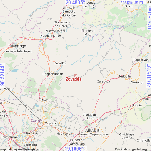
Zoyatitla GPS coordinates[2]
19° 49' 24.348" North, 97° 49' 5.916" West
| Map corner | latitude | longitude |
|---|---|---|
| Upper-left | 20.4835°, | -98.52144° |
| Center: | 19.82343°, | -97.81831° |
| Lower-right: | 19.16061°, | -97.11519° |
| Map W x H: | 147.1×147.1 km | = 91.4×91.4mi |
| max Lat: | 32.7° ⇑46.6% North |
| Zoyatitla: | 19.82343° |
| min Lat: | ⇓53.4% South 14.53588° |
| min Long | Zoyatitla | max Long |
| -117.105° | -97.81831° | -86.73105° |
| W 65.8%⇐ | ⇒34.2% E |
Elevation
Elevation of Zoyatitla is 1724 m = 5656 ft, and this is 470.3 m = 1543 ft above average elevation for this country.
| Max E: |
3497 m = 11473 ft | 40.1% |
| Zoyatitla | 1724 m 5656 ft | |
| Avg. | 1253.7 m = 4113 ft | |
Min E: |
-1 m = -3 ft | 59.9% |
See also: Mexico elevation on elevation.city.
Geographical zone
Zoyatitla is located in North Torrid zone (between Equator and Tropic of Cancer). Distance of this Northern Tropic circle is 401.8 km =249.7 mi to North.| Distance of | km | miles | from Zoyatitla |
|---|---|---|---|
| North Pole | 7802.9 | 4848.5 | to North |
| Arctic Circle | 5197 | 3229.3 | to North |
| Tropic Cancer | 401.8 | 249.7 | to North |
| Equator | 2204.2 | 1369.6 | to South |


Nearby cities:
15 places around Zoyatitla: (largest is in red/bold)
• Ahuatlán
10.5 km =6.5 mi,  4°
4°
• Aquixtla
12.6 km =7.8 mi,  255°
255°
• Atexcac
11.1 km =6.9 mi, 264°
• Benito Juárez
2.9 km =1.8 mi,  105°
105°
• Cerro Verde (Ejecatepeco)
11.6 km =7.2 mi,  12°
12°
• Cuapancingo
3.6 km =2.2 mi,  272°
272°
• Cuautempan
10.3 km =6.4 mi, 13°
• Cuautieco
11.8 km =7.3 mi,  247°
247°
• Hueytentan
6.4 km =4 mi,  355°
355°
• Ixtolco de Morelos
9.1 km =5.7 mi, 0°
• Tetela de Ocampo
1.4 km =0.9 mi,  118°
118°
• Tonalapa
6.6 km =4.1 mi, 260°
• Totomoxtla
12.4 km =7.7 mi, 4°
• Vista Hermosa
10.3 km =6.4 mi,  21°
21°
• Xaltatempa de Lucas
6.8 km =4.2 mi,  334°
334°
Sources, notices
• [Note1] Compared only with cities in Mexico existing in our database
• [Src1] Map data: © OpenStreetMap contributors (CC-BY-SA)
• [Src2] Other city data from geonames.org with taken over terms of usage.
• [Src3] Geographical zone / Annual Mean Temperature by Robert A. Rohde @ Wikipedia
