El Terrero geodata
El Terrero (Puebla) is a populated place; located in Mexico in America/Mexico_City (GMT-6) time zone. With population of 930 people, there are 9378 cities with bigger population in this country. Compared to other cities in Mexico, 52.5% of cities are located further ↓South; 64.2% of cities are located further ←West and 84.8% of cities have lower elevation than El Terrero. Note1


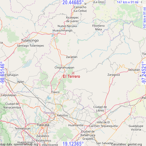
El Terrero GPS coordinates[2]
19° 47' 11.832" North, 97° 56' 53.988" West
| Map corner | latitude | longitude |
|---|---|---|
| Upper-left | 20.44685°, | -98.65146° |
| Center: | 19.78662°, | -97.94833° |
| Lower-right: | 19.12365°, | -97.24521° |
| Map W x H: | 147.1×147.1 km | = 91.4×91.4mi |
| max Lat: | 32.7° ⇑47.5% North |
| El Terrero: | 19.78662° |
| min Lat: | ⇓52.5% South 14.53588° |
| min Long | El Terrero | max Long |
| -117.105° | -97.94833° | -86.73105° |
| W 64.2%⇐ | ⇒35.8% E |
Elevation
Elevation of El Terrero is 2256 m = 7402 ft, and this is 1002.3 m = 3288 ft above average elevation for this country.
| Max E: |
3497 m = 11473 ft | 15.2% |
| El Terrero | 2256 m 7402 ft | |
| Avg. | 1253.7 m = 4113 ft | |
Min E: |
-1 m = -3 ft | 84.8% |
See also: Mexico elevation on elevation.city.
Geographical zone
El Terrero is located in North Torrid zone (between Equator and Tropic of Cancer). Distance of this Northern Tropic circle is 405.9 km =252.2 mi to North.| Distance of | km | miles | from El Terrero |
|---|---|---|---|
| North Pole | 7807 | 4851 | to North |
| Arctic Circle | 5201.1 | 3231.8 | to North |
| Tropic Cancer | 405.9 | 252.2 | to North |
| Equator | 2200.1 | 1367.1 | to South |


Nearby cities:
15 places around El Terrero: (largest is in red/bold)
• Aquixtla
1.7 km =1.1 mi,  52°
52°
• Atexcac
3.9 km =2.4 mi,  41°
41°
• Chichicaxtla
5.1 km =3.2 mi,  206°
206°
• Chignahuapan
10.5 km =6.5 mi,  303°
303°
• Coacoyunga
9 km =5.6 mi,  289°
289°
• Cuapancingo
10.9 km =6.8 mi,  67°
67°
• Cuautieco
2.7 km =1.7 mi,  100°
100°
• Ixtlahuaca Barrio
9 km =5.6 mi,  310°
310°
• Loma Alta
8.3 km =5.2 mi,  278°
278°
• Lázaro Cárdenas (Tzitla)
11.5 km =7.1 mi, 286°
• Matlahuacales Aquiles Serdán
11.4 km =7.1 mi,  256°
256°
• Sebastopol
7.7 km =4.8 mi, 263°
• Tenextla
8.4 km =5.2 mi, 308°
• Tomatlán
12.2 km =7.6 mi,  347°
347°
• Tonalapa
7.7 km =4.8 mi, 67°
Sources, notices
• [Note1] Compared only with cities in Mexico existing in our database
• [Src1] Map data: © OpenStreetMap contributors (CC-BY-SA)
• [Src2] Other city data from geonames.org with taken over terms of usage.
• [Src3] Geographical zone / Annual Mean Temperature by Robert A. Rohde @ Wikipedia
