Tlaltengo geodata
Tlaltengo (Veracruz) is a populated place; located in Mexico in America/Mexico_City (GMT-6) time zone. With population of 906 people, there are 9634 cities with bigger population in this country. Compared to other cities in Mexico, 63.4% of cities are located further ↑North; 74.8% of cities are located further ←West and 51% of cities have lower elevation than Tlaltengo. Note1


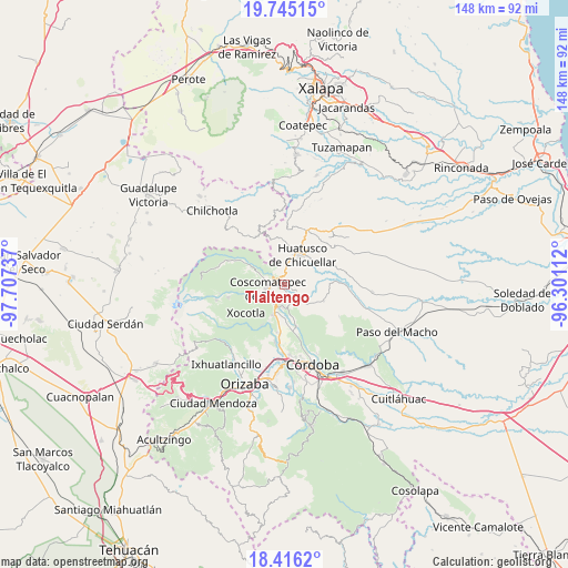
Tlaltengo GPS coordinates[2]
19° 4' 55.236" North, 97° 0' 15.264" West
| Map corner | latitude | longitude |
|---|---|---|
| Upper-left | 19.74515°, | -97.70737° |
| Center: | 19.08201°, | -97.00424° |
| Lower-right: | 18.4162°, | -96.30112° |
| Map W x H: | 147.8×147.8 km | = 91.8×91.8mi |
| max Lat: | 32.7° ⇑63.4% North |
| Tlaltengo: | 19.08201° |
| min Lat: | ⇓36.6% South 14.53588° |
| min Long | Tlaltengo | max Long |
| -117.105° | -97.00424° | -86.73105° |
| W 74.8%⇐ | ⇒25.2% E |
Elevation
Elevation of Tlaltengo is 1481 m = 4859 ft, and this is 227.3 m = 746 ft above average elevation for this country.
| Max E: |
3497 m = 11473 ft | 49% |
| Tlaltengo | 1481 m 4859 ft | |
| Avg. | 1253.7 m = 4113 ft | |
Min E: |
-1 m = -3 ft | 51% |
See also: Mexico elevation on elevation.city.
Geographical zone
Tlaltengo is located in North Torrid zone (between Equator and Tropic of Cancer). Distance of this Northern Tropic circle is 484.2 km =300.9 mi to North.| Distance of | km | miles | from Tlaltengo |
|---|---|---|---|
| North Pole | 7885.3 | 4899.7 | to North |
| Arctic Circle | 5279.5 | 3280.5 | to North |
| Tropic Cancer | 484.2 | 300.9 | to North |
| Equator | 2121.7 | 1318.4 | to South |


Nearby cities:
15 places around Tlaltengo: (largest is in red/bold)
• Alta Luz
5.7 km =3.5 mi,  85°
85°
• Colonia Francisco I. Madero
5 km =3.1 mi,  7°
7°
• Coscomatepec de Bravo
4.6 km =2.9 mi,  257°
257°
• Gonzalo Vázquez Vela
5.8 km =3.6 mi,  240°
240°
• Ixhuatlán del Café
4 km =2.5 mi,  148°
148°
• Ixpila
5.6 km =3.5 mi,  44°
44°
• Lázaro Cárdenas
2.6 km =1.6 mi,  272°
272°
• Michapa
5.9 km =3.7 mi,  63°
63°
• Nicanor Espejo
5.1 km =3.2 mi, 243°
• Presidio
3.7 km =2.3 mi,  112°
112°
• Tomatlán
5.7 km =3.5 mi,  185°
185°
• Tozongo
6.3 km =3.9 mi,  288°
288°
• Tres Aguas
6.4 km =4 mi,  313°
313°
• Xalatlaco
5.3 km =3.3 mi,  227°
227°
• Úrsulo Galván
4.3 km =2.7 mi,  275°
275°
Sources, notices
• [Note1] Compared only with cities in Mexico existing in our database
• [Src1] Map data: © OpenStreetMap contributors (CC-BY-SA)
• [Src2] Other city data from geonames.org with taken over terms of usage.
• [Src3] Geographical zone / Annual Mean Temperature by Robert A. Rohde @ Wikipedia
