Ixpila geodata
Ixpila (Veracruz) is a populated place; located in Mexico in America/Mexico_City (GMT-6) time zone. With population of 1,424 people, there are 6068 cities with bigger population in this country. Compared to other cities in Mexico, 62.8% of cities are located further ↑North; 75.3% of cities are located further ←West and 56.7% of cities have higher elevation than Ixpila. Note1


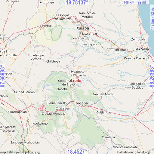
Ixpila GPS coordinates[2]
19° 7' 6.132" North, 96° 58' 0.3" West
| Map corner | latitude | longitude |
|---|---|---|
| Upper-left | 19.78137°, | -97.66988° |
| Center: | 19.11837°, | -96.96675° |
| Lower-right: | 18.4527°, | -96.26363° |
| Map W x H: | 147.7×147.7 km | = 91.8×91.8mi |
| max Lat: | 32.7° ⇑62.8% North |
| Ixpila: | 19.11837° |
| min Lat: | ⇓37.2% South 14.53588° |
| min Long | Ixpila | max Long |
| -117.105° | -96.96675° | -86.73105° |
| W 75.3%⇐ | ⇒24.7% E |
Elevation
Elevation of Ixpila is 1133 m = 3717 ft, and this is 120.7 m = 396 ft below average elevation for this country.
| Max E: |
3497 m = 11473 ft | 56.7% |
| Avg. | 1253.7 m = 4113 ft | |
| Ixpila | 1133 m = 3717 ft | |
Min E: |
-1 m = -3 ft | 43.3% |
See also: Mexico elevation on elevation.city.
Geographical zone
Ixpila is located in North Torrid zone (between Equator and Tropic of Cancer). Distance of this Northern Tropic circle is 480.2 km =298.4 mi to North.| Distance of | km | miles | from Ixpila |
|---|---|---|---|
| North Pole | 7881.3 | 4897.2 | to North |
| Arctic Circle | 5275.4 | 3278 | to North |
| Tropic Cancer | 480.2 | 298.4 | to North |
| Equator | 2125.8 | 1320.9 | to South |


Nearby cities:
15 places around Ixpila: (largest is in red/bold)
• Adolfo Ruiz Cortines (La Pastoría)
4.6 km =2.9 mi,  310°
310°
• Alta Luz
4 km =2.5 mi,  154°
154°
• Amatiopa
2.6 km =1.6 mi,  104°
104°
• Colonia Francisco I. Madero
3.4 km =2.1 mi,  285°
285°
• Colonia Pastoría Cuatro
4 km =2.5 mi,  333°
333°
• Huatusco
3.4 km =2.1 mi,  358°
358°
• Ixcatla
6.9 km =4.3 mi,  133°
133°
• Ixhuatlán del Café
7.7 km =4.8 mi,  193°
193°
• Mesa del Rancho
2.1 km =1.3 mi,  61°
61°
• Michapa
2 km =1.2 mi,  137°
137°
• Presidio
5.5 km =3.4 mi, 185°
• Tepampa
6.4 km =4 mi, 294°
• Tlaltengo
5.6 km =3.5 mi,  224°
224°
• Tlamatoca
4.2 km =2.6 mi, 131°
• Tomatlancillo
7.6 km =4.7 mi,  29°
29°
Sources, notices
• [Note1] Compared only with cities in Mexico existing in our database
• [Src1] Map data: © OpenStreetMap contributors (CC-BY-SA)
• [Src2] Other city data from geonames.org with taken over terms of usage.
• [Src3] Geographical zone / Annual Mean Temperature by Robert A. Rohde @ Wikipedia
