Tlacotepec de Mejía geodata
Tlacotepec de Mejía (Veracruz) is a seat of a second-order administrative division; located in Mexico in America/Mexico_City (GMT-6) time zone. With population of 2,401 people, there are 3678 cities with bigger population in this country. Compared to other cities in Mexico, 61.4% of cities are located further ↑North; 76.8% of cities are located further ←West and 61.6% of cities have higher elevation than Tlacotepec de Mejía. Note1


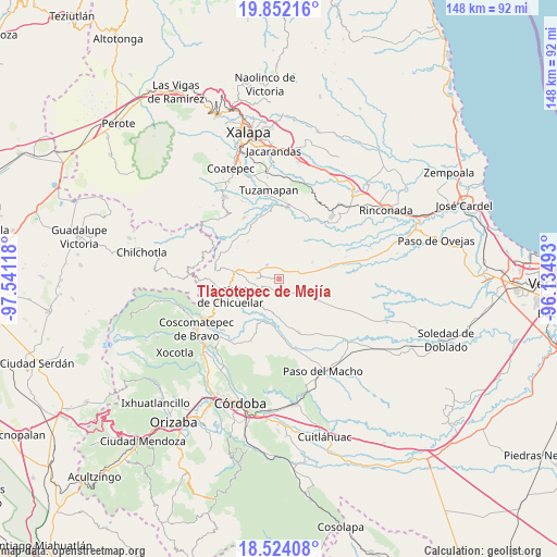
Tlacotepec de Mejía GPS coordinates[2]
19° 11' 22.056" North, 96° 50' 16.98" West
| Map corner | latitude | longitude |
|---|---|---|
| Upper-left | 19.85216°, | -97.54118° |
| Center: | 19.18946°, | -96.83805° |
| Lower-right: | 18.52408°, | -96.13493° |
| Map W x H: | 147.7×147.7 km | = 91.8×91.8mi |
| max Lat: | 32.7° ⇑61.4% North |
| Tlacotepec de Mejía: | 19.18946° |
| min Lat: | ⇓38.6% South 14.53588° |
| min Long | Tlacotepec de M | max Long |
| -117.105° | -96.83805° | -86.73105° |
| W 76.8%⇐ | ⇒23.2% E |
Elevation
Elevation of Tlacotepec de Mejía is 903 m = 2963 ft, and this is 350.7 m = 1151 ft below average elevation for this country.
| Max E: |
3497 m = 11473 ft | 61.6% |
| Avg. | 1253.7 m = 4113 ft | |
| Tlacotepec de Mejía | 903 m = 2963 ft | |
Min E: |
-1 m = -3 ft | 38.4% |
See also: Mexico elevation on elevation.city.
Geographical zone
Tlacotepec de Mejía is located in North Torrid zone (between Equator and Tropic of Cancer). Distance of this Northern Tropic circle is 472.3 km =293.5 mi to North.| Distance of | km | miles | from Tlacotepec de Mejía |
|---|---|---|---|
| North Pole | 7873.4 | 4892.3 | to North |
| Arctic Circle | 5267.5 | 3273.1 | to North |
| Tropic Cancer | 472.3 | 293.5 | to North |
| Equator | 2133.7 | 1325.8 | to South |


Nearby cities:
15 places around Tlacotepec de Mejía: (largest is in red/bold)
• Boca del Monte
3.9 km =2.4 mi,  171°
171°
• Chavaxtla
6.6 km =4.1 mi, 173°
• Chixtla
1.9 km =1.2 mi,  233°
233°
• Colonia Manuel González
8.6 km =5.3 mi,  195°
195°
• Colonia San José
7.2 km =4.5 mi,  337°
337°
• Comapa
5.8 km =3.6 mi,  240°
240°
• Cosolapo
9.2 km =5.7 mi,  282°
282°
• Coyolito
5.4 km =3.4 mi,  321°
321°
• Mata Obscura
3.6 km =2.2 mi,  331°
331°
• Mata de Indio
4.6 km =2.9 mi,  355°
355°
• Mata de Jobo
9.9 km =6.2 mi,  63°
63°
• Puentecilla
10.5 km =6.5 mi,  187°
187°
• Sochiapa
10.7 km =6.6 mi,  272°
272°
• Tenampa
8.2 km =5.1 mi, 323°
• Tomatlancillo
9.9 km =6.2 mi,  262°
262°
Sources, notices
• [Note1] Compared only with cities in Mexico existing in our database
• [Src1] Map data: © OpenStreetMap contributors (CC-BY-SA)
• [Src2] Other city data from geonames.org with taken over terms of usage.
• [Src3] Geographical zone / Annual Mean Temperature by Robert A. Rohde @ Wikipedia
