Los Marías geodata
Los Marías (Puebla) is a populated place; located in Mexico in America/Mexico_City (GMT-6) time zone. With population of 651 people, there are 13306 cities with bigger population in this country. Compared to other cities in Mexico, 70% of cities are located further ↑North; 67.7% of cities are located further ←West and 73.1% of cities have lower elevation than Los Marías. Note1


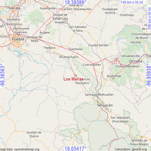
Los Marías GPS coordinates[2]
18° 43' 17.004" North, 97° 39' 45" West
| Map corner | latitude | longitude |
|---|---|---|
| Upper-left | 19.38599°, | -98.36563° |
| Center: | 18.72139°, | -97.6625° |
| Lower-right: | 18.05417°, | -96.95938° |
| Map W x H: | 148.1×148.1 km | = 92×92mi |
| max Lat: | 32.7° ⇑70% North |
| Los Marías: | 18.72139° |
| min Lat: | ⇓30% South 14.53588° |
| min Long | Los Marías | max Long |
| -117.105° | -97.6625° | -86.73105° |
| W 67.7%⇐ | ⇒32.3% E |
Elevation
Elevation of Los Marías is 1992 m = 6535 ft, and this is 738.3 m = 2422 ft above average elevation for this country.
| Max E: |
3497 m = 11473 ft | 26.9% |
| Los Marías | 1992 m 6535 ft | |
| Avg. | 1253.7 m = 4113 ft | |
Min E: |
-1 m = -3 ft | 73.1% |
See also: Mexico elevation on elevation.city.
Geographical zone
Los Marías is located in North Torrid zone (between Equator and Tropic of Cancer). Distance of this Northern Tropic circle is 524.3 km =325.8 mi to North.| Distance of | km | miles | from Los Marías |
|---|---|---|---|
| North Pole | 7925.4 | 4924.6 | to North |
| Arctic Circle | 5319.6 | 3305.4 | to North |
| Tropic Cancer | 524.3 | 325.8 | to North |
| Equator | 2081.6 | 1293.4 | to South |


Nearby cities:
15 places around Los Marías: (largest is in red/bold)
• Guadalupe Victoria
7.6 km =4.7 mi,  221°
221°
• Ocotlán de Venustiano Carranza
7.8 km =4.8 mi,  354°
354°
• Rancho Chico
2.8 km =1.7 mi, 354°
• San Gabriel Tetzoyocán
5.9 km =3.7 mi,  312°
312°
• San José Tlacuitlapan
4.2 km =2.6 mi,  111°
111°
• San Lucas el Viejo
7.7 km =4.8 mi,  230°
230°
• San Marcos Tlacoyalco
8.2 km =5.1 mi,  130°
130°
• San Miguel Zozutla
3.7 km =2.3 mi,  12°
12°
• Santo Nombre
5.5 km =3.4 mi,  195°
195°
• Tecalzingo
1.4 km =0.9 mi, 227°
• Tecoxtle
8.9 km =5.5 mi,  157°
157°
• Tepazolco
4.3 km =2.7 mi,  235°
235°
• Tlacomulco
1.9 km =1.2 mi,  23°
23°
• Tlacotepec
4.4 km =2.7 mi,  171°
171°
• Yehualtepec
8.2 km =5.1 mi,  0°
0°
Sources, notices
• [Note1] Compared only with cities in Mexico existing in our database
• [Src1] Map data: © OpenStreetMap contributors (CC-BY-SA)
• [Src2] Other city data from geonames.org with taken over terms of usage.
• [Src3] Geographical zone / Annual Mean Temperature by Robert A. Rohde @ Wikipedia
