Tecalzingo geodata
Tecalzingo (Puebla) is a populated place; located in Mexico in America/Mexico_City (GMT-6) time zone. With population of 821 people, there are 10634 cities with bigger population in this country. Compared to other cities in Mexico, 70.1% of cities are located further ↑North; 67.6% of cities are located further ←West and 72.2% of cities have lower elevation than Tecalzingo. Note1


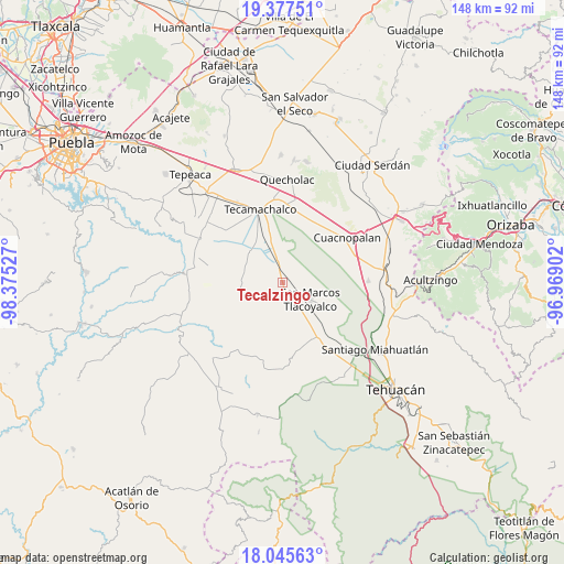
Tecalzingo GPS coordinates[2]
18° 42' 46.368" North, 97° 40' 19.704" West
| Map corner | latitude | longitude |
|---|---|---|
| Upper-left | 19.37751°, | -98.37527° |
| Center: | 18.71288°, | -97.67214° |
| Lower-right: | 18.04563°, | -96.96902° |
| Map W x H: | 148.1×148.1 km | = 92×92mi |
| max Lat: | 32.7° ⇑70.1% North |
| Tecalzingo: | 18.71288° |
| min Lat: | ⇓29.9% South 14.53588° |
| min Long | Tecalzingo | max Long |
| -117.105° | -97.67214° | -86.73105° |
| W 67.6%⇐ | ⇒32.4% E |
Elevation
Elevation of Tecalzingo is 1971 m = 6467 ft, and this is 717.3 m = 2353 ft above average elevation for this country.
| Max E: |
3497 m = 11473 ft | 27.8% |
| Tecalzingo | 1971 m 6467 ft | |
| Avg. | 1253.7 m = 4113 ft | |
Min E: |
-1 m = -3 ft | 72.2% |
See also: Mexico elevation on elevation.city.
Geographical zone
Tecalzingo is located in North Torrid zone (between Equator and Tropic of Cancer). Distance of this Northern Tropic circle is 525.2 km =326.3 mi to North.| Distance of | km | miles | from Tecalzingo |
|---|---|---|---|
| North Pole | 7926.4 | 4925.2 | to North |
| Arctic Circle | 5320.5 | 3306 | to North |
| Tropic Cancer | 525.2 | 326.3 | to North |
| Equator | 2080.7 | 1292.9 | to South |


Nearby cities:
15 places around Tecalzingo: (largest is in red/bold)
• Guadalupe Victoria
6.3 km =3.9 mi,  219°
219°
• Los Marías
1.4 km =0.9 mi,  47°
47°
• Ocotlán de Venustiano Carranza
8.7 km =5.4 mi,  2°
2°
• Rancho Chico
3.8 km =2.4 mi,  11°
11°
• San Gabriel Tetzoyocán
5.9 km =3.7 mi,  326°
326°
• San José Tlacuitlapan
5 km =3.1 mi,  96°
96°
• San Lucas el Viejo
6.3 km =3.9 mi,  230°
230°
• San Marcos Tlacoyalco
8.4 km =5.2 mi,  120°
120°
• San Miguel Zozutla
5 km =3.1 mi,  21°
21°
• Santo Nombre
4.4 km =2.7 mi,  185°
185°
• Tecoxtle
8.5 km =5.3 mi,  148°
148°
• Tepazolco
2.9 km =1.8 mi,  240°
240°
• Tepetlacolco
8.3 km =5.2 mi,  195°
195°
• Tlacomulco
3.2 km =2 mi,  33°
33°
• Tlacotepec
3.8 km =2.4 mi, 153°
Sources, notices
• [Note1] Compared only with cities in Mexico existing in our database
• [Src1] Map data: © OpenStreetMap contributors (CC-BY-SA)
• [Src2] Other city data from geonames.org with taken over terms of usage.
• [Src3] Geographical zone / Annual Mean Temperature by Robert A. Rohde @ Wikipedia
