Saban geodata
Saban (Quintana Roo) is a populated place; located in Mexico in America/Cancun (GMT-5) time zone. With population of 2,167 people, there are 4058 cities with bigger population in this country. Compared to other cities in Mexico, 57.7% of cities are located further ↓South; 99.2% of cities are located further ←West and 88% of cities have higher elevation than Saban. Note1


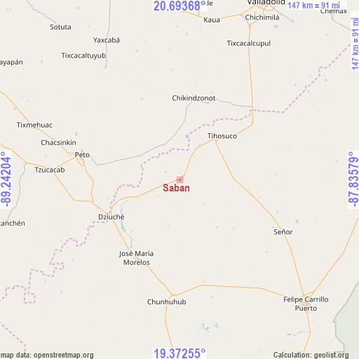
Saban GPS coordinates[2]
20° 2' 4.2" North, 88° 32' 20.076" West
| Map corner | latitude | longitude |
|---|---|---|
| Upper-left | 20.69368°, | -89.24204° |
| Center: | 20.0345°, | -88.53891° |
| Lower-right: | 19.37255°, | -87.83579° |
| Map W x H: | 146.9×146.9 km | = 91.3×91.3mi |
| max Lat: | 32.7° ⇑42.3% North |
| Saban: | 20.0345° |
| min Lat: | ⇓57.7% South 14.53588° |
| min Long | Saban | max Long |
| -117.105° | -88.53891° | -86.73105° |
| W 99.2%⇐ | ⇒0.8% E |
Elevation
Elevation of Saban is 30 m = 98 ft, and this is 1223.7 m = 4015 ft below average elevation for this country.
| Max E: |
3497 m = 11473 ft | 88% |
| Avg. | 1253.7 m = 4113 ft | |
| Saban | 30 m = 98 ft | |
Min E: |
-1 m = -3 ft | 12% |
See also: Mexico elevation on elevation.city.
Geographical zone
Saban is located in North Torrid zone (between Equator and Tropic of Cancer). Distance of this Northern Tropic circle is 378.3 km =235.1 mi to North.| Distance of | km | miles | from Saban |
|---|---|---|---|
| North Pole | 7779.4 | 4833.9 | to North |
| Arctic Circle | 5173.5 | 3214.7 | to North |
| Tropic Cancer | 378.3 | 235.1 | to North |
| Equator | 2227.6 | 1384.2 | to South |


Nearby cities:
15 places around Saban: (largest is in red/bold)
• Bulukax
25.6 km =15.9 mi,  252°
252°
• Chikindzonot
33.8 km =21 mi,  9°
9°
• Dziuche
32.1 km =19.9 mi,  241°
241°
• Ekpedz
33.3 km =20.7 mi,  19°
19°
• Filomeno Mata
24.6 km =15.3 mi,  142°
142°
• Huay Max
1.6 km =1 mi,  59°
59°
• Ichmul
16 km =9.9 mi,  333°
333°
• La Esperanza
19.5 km =12.1 mi,  194°
194°
• La Presumida
34.4 km =21.4 mi,  220°
220°
• San Diego
29 km =18 mi, 223°
• Santa Gertrudis
35.7 km =22.2 mi, 223°
• Santa Rosa Segundo
29.6 km =18.4 mi,  102°
102°
• Tihosuco
24.9 km =15.5 mi,  43°
43°
• X Cabil
16.5 km =10.3 mi,  28°
28°
• Zacalaca
6.7 km =4.2 mi,  297°
297°
Sources, notices
• [Note1] Compared only with cities in Mexico existing in our database
• [Src1] Map data: © OpenStreetMap contributors (CC-BY-SA)
• [Src2] Other city data from geonames.org with taken over terms of usage.
• [Src3] Geographical zone / Annual Mean Temperature by Robert A. Rohde @ Wikipedia
