Chumpón geodata
Chumpón (Quintana Roo) is a populated place; located in Mexico in America/Cancun (GMT-5) time zone. With population of 717 people, there are 12151 cities with bigger population in this country. Compared to other cities in Mexico, 57% of cities are located further ↓South; 99.8% of cities are located further ←West and 98.1% of cities have higher elevation than Chumpón. Note1


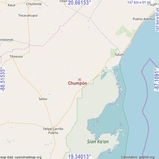
Chumpón GPS coordinates[2]
20° 0' 7.992" North, 87° 48' 43.992" West
| Map corner | latitude | longitude |
|---|---|---|
| Upper-left | 20.66153°, | -88.51535° |
| Center: | 20.00222°, | -87.81222° |
| Lower-right: | 19.34013°, | -87.1091° |
| Map W x H: | 146.9×146.9 km | = 91.3×91.3mi |
| max Lat: | 32.7° ⇑43% North |
| Chumpón: | 20.00222° |
| min Lat: | ⇓57% South 14.53588° |
| min Long | Chumpón | max Long |
| -117.105° | -87.81222° | -86.73105° |
| W 99.8%⇐ | ⇒0.2% E |
Elevation
Elevation of Chumpón is 8 m = 26 ft, and this is 1245.7 m = 4087 ft below average elevation for this country.
| Max E: |
3497 m = 11473 ft | 98.1% |
| Avg. | 1253.7 m = 4113 ft | |
| Chumpón | 8 m = 26 ft | |
Min E: |
-1 m = -3 ft | 1.9% |
See also: Mexico elevation on elevation.city.
Geographical zone
Chumpón is located in North Torrid zone (between Equator and Tropic of Cancer). Distance of this Northern Tropic circle is 381.9 km =237.3 mi to North.| Distance of | km | miles | from Chumpón |
|---|---|---|---|
| North Pole | 7783 | 4836.1 | to North |
| Arctic Circle | 5177.1 | 3216.9 | to North |
| Tropic Cancer | 381.9 | 237.3 | to North |
| Equator | 2224 | 1381.9 | to South |


Nearby cities:
15 places around Chumpón: (largest is in red/bold)
• Chan X-Cail
52.3 km =32.5 mi,  318°
318°
• Chanchen Primero
47.2 km =29.3 mi,  339°
339°
• Chun-Yah
16.2 km =10.1 mi,  312°
312°
• Dzitox
51.1 km =31.8 mi,  325°
325°
• Felipe Carrillo Puerto
53.1 km =33 mi,  207°
207°
• Francisco Uh May
46.5 km =28.9 mi,  29°
29°
• Macario Gómez
46 km =28.6 mi, 32°
• San Silverio
46.1 km =28.6 mi, 329°
• Santa Rosa Segundo
47.1 km =29.3 mi,  266°
266°
• Señor
38.1 km =23.7 mi,  242°
242°
• Tepich
53.5 km =33.2 mi,  299°
299°
• Tixcacal Guardia
41.1 km =25.5 mi,  247°
247°
• Tulum
43.2 km =26.8 mi,  57°
57°
• Tuzik
37.6 km =23.4 mi,  255°
255°
• Yaxley
48.1 km =29.9 mi, 237°
Sources, notices
• [Note1] Compared only with cities in Mexico existing in our database
• [Src1] Map data: © OpenStreetMap contributors (CC-BY-SA)
• [Src2] Other city data from geonames.org with taken over terms of usage.
• [Src3] Geographical zone / Annual Mean Temperature by Robert A. Rohde @ Wikipedia
