Tepeitic geodata
Tepeitic (Hidalgo) is a populated place; located in Mexico in America/Mexico_City (GMT-6) time zone. With population of 1,560 people, there are 5531 cities with bigger population in this country. Compared to other cities in Mexico, 62.3% of cities are located further ↓South; 54.1% of cities are located further →East and 75.9% of cities have lower elevation than Tepeitic. Note1


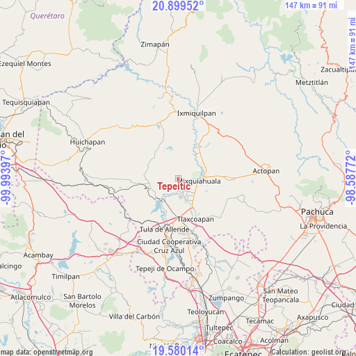
Tepeitic GPS coordinates[2]
20° 14' 28.428" North, 99° 17' 27.024" West
| Map corner | latitude | longitude |
|---|---|---|
| Upper-left | 20.89952°, | -99.99397° |
| Center: | 20.24123°, | -99.29084° |
| Lower-right: | 19.58014°, | -98.58772° |
| Map W x H: | 146.7×146.7 km | = 91.2×91.2mi |
| max Lat: | 32.7° ⇑37.7% North |
| Tepeitic: | 20.24123° |
| min Lat: | ⇓62.3% South 14.53588° |
| min Long | Tepeitic | max Long |
| -117.105° | -99.29084° | -86.73105° |
| W 45.9%⇐ | ⇒54.1% E |
Elevation
Elevation of Tepeitic is 2046 m = 6713 ft, and this is 792.3 m = 2599 ft above average elevation for this country.
| Max E: |
3497 m = 11473 ft | 24.1% |
| Tepeitic | 2046 m 6713 ft | |
| Avg. | 1253.7 m = 4113 ft | |
Min E: |
-1 m = -3 ft | 75.9% |
See also: Mexico elevation on elevation.city.
Geographical zone
Tepeitic is located in North Torrid zone (between Equator and Tropic of Cancer). Distance of this Northern Tropic circle is 355.3 km =220.8 mi to North.| Distance of | km | miles | from Tepeitic |
|---|---|---|---|
| North Pole | 7756.4 | 4819.6 | to North |
| Arctic Circle | 5150.6 | 3200.4 | to North |
| Tropic Cancer | 355.3 | 220.8 | to North |
| Equator | 2250.6 | 1398.5 | to South |


Nearby cities:
15 places around Tepeitic: (largest is in red/bold)
• Colonia Huitexcalco
2.9 km =1.8 mi,  29°
29°
• Colonia San Juan
5.7 km =3.5 mi,  171°
171°
• La Loma
7.6 km =4.7 mi,  157°
157°
• La Palma
4.6 km =2.9 mi,  126°
126°
• Mangas
7.6 km =4.7 mi,  143°
143°
• Mixquiahuala de Juarez
8.1 km =5 mi,  98°
98°
• Panuaya
5.5 km =3.4 mi, 157°
• San Isidro el Tanque
7.4 km =4.6 mi,  176°
176°
• San Juan Achichilco
7.4 km =4.6 mi,  199°
199°
• Santa María Batha
4.5 km =2.8 mi,  114°
114°
• Santiago Acayutlán
4.9 km =3 mi,  185°
185°
• Tenango
1.6 km =1 mi, 179°
• Texcatepec
5.5 km =3.4 mi,  44°
44°
• Tezontepec de Aldama
5.9 km =3.7 mi, 162°
• Tunititlán
4.9 km =3 mi,  79°
79°
Sources, notices
• [Note1] Compared only with cities in Mexico existing in our database
• [Src1] Map data: © OpenStreetMap contributors (CC-BY-SA)
• [Src2] Other city data from geonames.org with taken over terms of usage.
• [Src3] Geographical zone / Annual Mean Temperature by Robert A. Rohde @ Wikipedia
