Santiago Tenango geodata
Santiago Tenango (Puebla) is a populated place; located in Mexico in America/Mexico_City (GMT-6) time zone. With population of 4,870 people, there are 1897 cities with bigger population in this country. Compared to other cities in Mexico, 64.6% of cities are located further ↑North; 68% of cities are located further ←West and 86.4% of cities have lower elevation than Santiago Tenango. Note1


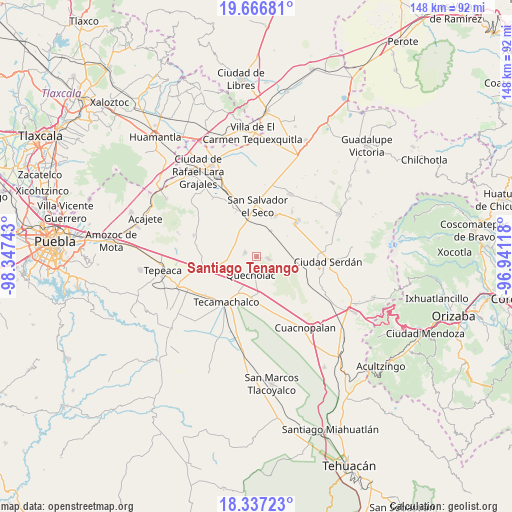
Santiago Tenango GPS coordinates[2]
19° 0' 12.06" North, 97° 38' 39.48" West
| Map corner | latitude | longitude |
|---|---|---|
| Upper-left | 19.66681°, | -98.34743° |
| Center: | 19.00335°, | -97.6443° |
| Lower-right: | 18.33723°, | -96.94118° |
| Map W x H: | 147.8×147.8 km | = 91.8×91.8mi |
| max Lat: | 32.7° ⇑64.6% North |
| Santiago Tenango: | 19.00335° |
| min Lat: | ⇓35.4% South 14.53588° |
| min Long | Santiago Tenang | max Long |
| -117.105° | -97.6443° | -86.73105° |
| W 68%⇐ | ⇒32% E |
Elevation
Elevation of Santiago Tenango is 2292 m = 7520 ft, and this is 1038.3 m = 3406 ft above average elevation for this country.
| Max E: |
3497 m = 11473 ft | 13.6% |
| Santiago Tenango | 2292 m 7520 ft | |
| Avg. | 1253.7 m = 4113 ft | |
Min E: |
-1 m = -3 ft | 86.4% |
See also: Mexico elevation on elevation.city.
Geographical zone
Santiago Tenango is located in North Torrid zone (between Equator and Tropic of Cancer). Distance of this Northern Tropic circle is 492.9 km =306.3 mi to North.| Distance of | km | miles | from Santiago Tenango |
|---|---|---|---|
| North Pole | 7894.1 | 4905.2 | to North |
| Arctic Circle | 5288.2 | 3285.9 | to North |
| Tropic Cancer | 492.9 | 306.3 | to North |
| Equator | 2113 | 1313 | to South |


Nearby cities:
15 places around Santiago Tenango: (largest is in red/bold)
• Candelaria Portezuelo
7.3 km =4.5 mi,  305°
305°
• Francisco I. Madero
9.1 km =5.7 mi,  206°
206°
• La Compañia
9 km =5.6 mi,  246°
246°
• Palmarito Tochapan
11.4 km =7.1 mi,  176°
176°
• Quecholac
5.6 km =3.5 mi,  195°
195°
• San Antonio Portezuelo
7.3 km =4.5 mi,  266°
266°
• San Bartolomé
9.9 km =6.2 mi,  164°
164°
• San Cayetano
9.3 km =5.8 mi,  172°
172°
• San José Guerrero
11.2 km =7 mi,  95°
95°
• San Pablo de las Tunas
6.9 km =4.3 mi,  262°
262°
• San Sebastián Villanueva
10.2 km =6.3 mi, 309°
• San Simón
8.2 km =5.1 mi,  240°
240°
• Santa Catarina Villanueva
3.1 km =1.9 mi, 98°
• Santa Cruz Coyotepec
9 km =5.6 mi,  76°
76°
• Tuzuapan
11.6 km =7.2 mi,  191°
191°
Sources, notices
• [Note1] Compared only with cities in Mexico existing in our database
• [Src1] Map data: © OpenStreetMap contributors (CC-BY-SA)
• [Src2] Other city data from geonames.org with taken over terms of usage.
• [Src3] Geographical zone / Annual Mean Temperature by Robert A. Rohde @ Wikipedia
