Tuzuapan geodata
Tuzuapan (Puebla) is a populated place; located in Mexico in America/Mexico_City (GMT-6) time zone. With population of 3,404 people, there are 2671 cities with bigger population in this country. Compared to other cities in Mexico, 67% of cities are located further ↑North; 67.7% of cities are located further ←West and 80% of cities have lower elevation than Tuzuapan. Note1


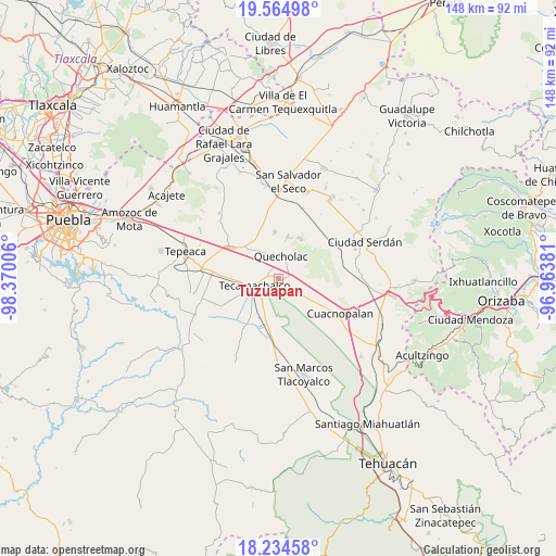
Tuzuapan GPS coordinates[2]
18° 54' 3.96" North, 97° 40' 0.948" West
| Map corner | latitude | longitude |
|---|---|---|
| Upper-left | 19.56498°, | -98.37006° |
| Center: | 18.9011°, | -97.66693° |
| Lower-right: | 18.23458°, | -96.96381° |
| Map W x H: | 147.9×147.9 km | = 91.9×91.9mi |
| max Lat: | 32.7° ⇑67% North |
| Tuzuapan: | 18.9011° |
| min Lat: | ⇓33% South 14.53588° |
| min Long | Tuzuapan | max Long |
| -117.105° | -97.66693° | -86.73105° |
| W 67.7%⇐ | ⇒32.3% E |
Elevation
Elevation of Tuzuapan is 2140 m = 7021 ft, and this is 886.3 m = 2908 ft above average elevation for this country.
| Max E: |
3497 m = 11473 ft | 20% |
| Tuzuapan | 2140 m 7021 ft | |
| Avg. | 1253.7 m = 4113 ft | |
Min E: |
-1 m = -3 ft | 80% |
See also: Mexico elevation on elevation.city.
Geographical zone
Tuzuapan is located in North Torrid zone (between Equator and Tropic of Cancer). Distance of this Northern Tropic circle is 504.3 km =313.4 mi to North.| Distance of | km | miles | from Tuzuapan |
|---|---|---|---|
| North Pole | 7905.5 | 4912.2 | to North |
| Arctic Circle | 5299.6 | 3293 | to North |
| Tropic Cancer | 504.3 | 313.4 | to North |
| Equator | 2101.6 | 1305.9 | to South |


Nearby cities:
15 places around Tuzuapan: (largest is in red/bold)
• Francisco I. Madero
3.6 km =2.2 mi,  331°
331°
• Guadalupe Enríquez
8.4 km =5.2 mi,  95°
95°
• Jesús Nazareno
5.4 km =3.4 mi,  120°
120°
• José María Pino Suárez
8.4 km =5.2 mi,  238°
238°
• Lomas de Romero
5.5 km =3.4 mi,  285°
285°
• Lomas de Santa Cruz
7.1 km =4.4 mi, 291°
• Palmarito Tochapan
3 km =1.9 mi,  89°
89°
• Quecholac
6 km =3.7 mi,  8°
8°
• San Bartolomé
5.4 km =3.4 mi,  69°
69°
• San Cayetano
4.2 km =2.6 mi,  59°
59°
• San Simón
8.8 km =5.5 mi, 327°
• Santiago Alseseca
7.5 km =4.7 mi,  214°
214°
• Tecamachalco
7.3 km =4.5 mi,  254°
254°
• Tlaixpan
7.6 km =4.7 mi,  279°
279°
• Xaltepec
6.5 km =4 mi,  109°
109°
Sources, notices
• [Note1] Compared only with cities in Mexico existing in our database
• [Src1] Map data: © OpenStreetMap contributors (CC-BY-SA)
• [Src2] Other city data from geonames.org with taken over terms of usage.
• [Src3] Geographical zone / Annual Mean Temperature by Robert A. Rohde @ Wikipedia
