San Cayetano geodata
San Cayetano (Puebla) is a populated place; located in Mexico in America/Mexico_City (GMT-6) time zone. With population of 533 people, there are 15888 cities with bigger population in this country. Compared to other cities in Mexico, 66.5% of cities are located further ↑North; 68.1% of cities are located further ←West and 81.7% of cities have lower elevation than San Cayetano. Note1


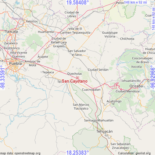
San Cayetano GPS coordinates[2]
18° 55' 13.008" North, 97° 37' 58.008" West
| Map corner | latitude | longitude |
|---|---|---|
| Upper-left | 19.58408°, | -98.33591° |
| Center: | 18.92028°, | -97.63278° |
| Lower-right: | 18.25383°, | -96.92966° |
| Map W x H: | 147.9×147.9 km | = 91.9×91.9mi |
| max Lat: | 32.7° ⇑66.5% North |
| San Cayetano: | 18.92028° |
| min Lat: | ⇓33.5% South 14.53588° |
| min Long | San Cayetano | max Long |
| -117.105° | -97.63278° | -86.73105° |
| W 68.1%⇐ | ⇒31.9% E |
Elevation
Elevation of San Cayetano is 2181 m = 7156 ft, and this is 927.3 m = 3042 ft above average elevation for this country.
| Max E: |
3497 m = 11473 ft | 18.3% |
| San Cayetano | 2181 m 7156 ft | |
| Avg. | 1253.7 m = 4113 ft | |
Min E: |
-1 m = -3 ft | 81.7% |
See also: Mexico elevation on elevation.city.
Geographical zone
San Cayetano is located in North Torrid zone (between Equator and Tropic of Cancer). Distance of this Northern Tropic circle is 502.2 km =312.1 mi to North.| Distance of | km | miles | from San Cayetano |
|---|---|---|---|
| North Pole | 7903.3 | 4910.9 | to North |
| Arctic Circle | 5297.4 | 3291.7 | to North |
| Tropic Cancer | 502.2 | 312.1 | to North |
| Equator | 2103.7 | 1307.2 | to South |


Nearby cities:
15 places around San Cayetano: (largest is in red/bold)
• Francisco I. Madero
5.4 km =3.4 mi,  281°
281°
• Guadalupe Enríquez
5.6 km =3.5 mi,  121°
121°
• Jesús Nazareno
5 km =3.1 mi,  168°
168°
• Lomas de Romero
8.9 km =5.5 mi,  265°
265°
• Lomas de Santa Cruz
10.2 km =6.3 mi, 272°
• Palmarito Tochapan
2.2 km =1.4 mi,  195°
195°
• Quecholac
4.7 km =2.9 mi,  324°
324°
• San Bartolomé
1.5 km =0.9 mi,  101°
101°
• San Isidro Monterrosas
9.3 km =5.8 mi,  139°
139°
• San Simón
9.8 km =6.1 mi,  302°
302°
• Santa Catarina Villanueva
9 km =5.6 mi,  12°
12°
• Santa Cruz Monterrosas
8.9 km =5.5 mi, 123°
• Santiago Tenango
9.3 km =5.8 mi,  352°
352°
• Tuzuapan
4.2 km =2.6 mi,  239°
239°
• Xaltepec
5 km =3.1 mi,  149°
149°
Sources, notices
• [Note1] Compared only with cities in Mexico existing in our database
• [Src1] Map data: © OpenStreetMap contributors (CC-BY-SA)
• [Src2] Other city data from geonames.org with taken over terms of usage.
• [Src3] Geographical zone / Annual Mean Temperature by Robert A. Rohde @ Wikipedia
