Tekik de Regil geodata
Tekik de Regil (Yucatán) is a populated place; located in Mexico in America/Merida (GMT-6) time zone. With population of 1,938 people, there are 4490 cities with bigger population in this country. Compared to other cities in Mexico, 73.5% of cities are located further ↓South; 98% of cities are located further ←West and 93.5% of cities have higher elevation than Tekik de Regil. Note1


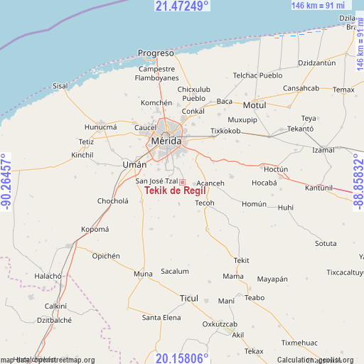
Tekik de Regil GPS coordinates[2]
20° 49' 0.156" North, 89° 33' 41.184" West
| Map corner | latitude | longitude |
|---|---|---|
| Upper-left | 21.47249°, | -90.26457° |
| Center: | 20.81671°, | -89.56144° |
| Lower-right: | 20.15806°, | -88.85832° |
| Map W x H: | 146.2×146.2 km | = 90.8×90.8mi |
| max Lat: | 32.7° ⇑26.5% North |
| Tekik de Regil: | 20.81671° |
| min Lat: | ⇓73.5% South 14.53588° |
| min Long | Tekik de Regil | max Long |
| -117.105° | -89.56144° | -86.73105° |
| W 98%⇐ | ⇒2% E |
Elevation
Elevation of Tekik de Regil is 16 m = 52 ft, and this is 1237.7 m = 4061 ft below average elevation for this country.
| Max E: |
3497 m = 11473 ft | 93.5% |
| Avg. | 1253.7 m = 4113 ft | |
| Tekik de Regil | 16 m = 52 ft | |
Min E: |
-1 m = -3 ft | 6.5% |
See also: Mexico elevation on elevation.city.
Geographical zone
Tekik de Regil is located in North Torrid zone (between Equator and Tropic of Cancer). Distance of this Northern Tropic circle is 291.3 km =181 mi to North.| Distance of | km | miles | from Tekik de Regil |
|---|---|---|---|
| North Pole | 7692.5 | 4779.9 | to North |
| Arctic Circle | 5086.6 | 3160.7 | to North |
| Tropic Cancer | 291.3 | 181 | to North |
| Equator | 2314.6 | 1438.2 | to South |


Nearby cities:
15 places around Tekik de Regil: (largest is in red/bold)
• Acanceh
11.3 km =7 mi,  92°
92°
• Dzununcan
11 km =6.8 mi,  299°
299°
• Leona Vicario
11.1 km =6.9 mi,  338°
338°
• Molas
7.1 km =4.4 mi,  269°
269°
• Petectunich
9.3 km =5.8 mi,  72°
72°
• San Antonio Tehuitz
10.2 km =6.3 mi,  24°
24°
• San José Tzal
10.3 km =6.4 mi, 274°
• San Pedro Chimay
5.7 km =3.5 mi, 340°
• Santa Cruz Palomeque
11.9 km =7.4 mi,  306°
306°
• Subinkancab
6.4 km =4 mi,  28°
28°
• Tahdzibichen
8.6 km =5.3 mi,  333°
333°
• Tepich Carrillo
9.4 km =5.8 mi,  44°
44°
• Timucuy
5 km =3.1 mi,  98°
98°
• Xmatkuíl
8.2 km =5.1 mi, 306°
• Yaxníc
6.7 km =4.2 mi,  243°
243°
Sources, notices
• [Note1] Compared only with cities in Mexico existing in our database
• [Src1] Map data: © OpenStreetMap contributors (CC-BY-SA)
• [Src2] Other city data from geonames.org with taken over terms of usage.
• [Src3] Geographical zone / Annual Mean Temperature by Robert A. Rohde @ Wikipedia
