Xmatkuíl geodata
Xmatkuíl (Yucatán) is a populated place; located in Mexico in America/Merida (GMT-6) time zone. With population of 526 people, there are 16064 cities with bigger population in this country. Compared to other cities in Mexico, 74.1% of cities are located further ↓South; 97.9% of cities are located further ←West and 95.7% of cities have higher elevation than Xmatkuíl. Note1


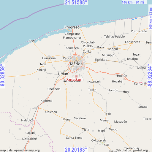
Xmatkuíl GPS coordinates[2]
20° 51' 37.044" North, 89° 37' 31.656" West
| Map corner | latitude | longitude |
|---|---|---|
| Upper-left | 21.51588°, | -90.32859° |
| Center: | 20.86029°, | -89.62546° |
| Lower-right: | 20.20183°, | -88.92234° |
| Map W x H: | 146.1×146.1 km | = 90.8×90.8mi |
| max Lat: | 32.7° ⇑25.9% North |
| Xmatkuíl: | 20.86029° |
| min Lat: | ⇓74.1% South 14.53588° |
| min Long | Xmatkuíl | max Long |
| -117.105° | -89.62546° | -86.73105° |
| W 97.9%⇐ | ⇒2.1% E |
Elevation
Elevation of Xmatkuíl is 12 m = 39 ft, and this is 1241.7 m = 4074 ft below average elevation for this country.
| Max E: |
3497 m = 11473 ft | 95.7% |
| Avg. | 1253.7 m = 4113 ft | |
| Xmatkuíl | 12 m = 39 ft | |
Min E: |
-1 m = -3 ft | 4.3% |
See also: Mexico elevation on elevation.city.
Geographical zone
Xmatkuíl is located in North Torrid zone (between Equator and Tropic of Cancer). Distance of this Northern Tropic circle is 286.5 km =178 mi to North.| Distance of | km | miles | from Xmatkuíl |
|---|---|---|---|
| North Pole | 7687.6 | 4776.9 | to North |
| Arctic Circle | 5081.7 | 3157.6 | to North |
| Tropic Cancer | 286.5 | 178 | to North |
| Equator | 2319.4 | 1441.2 | to South |


Nearby cities:
15 places around Xmatkuíl: (largest is in red/bold)
• Dzununcan
3 km =1.9 mi,  279°
279°
• Itzincab Palomeque
9.8 km =6.1 mi,  309°
309°
• Kanasín
10.8 km =6.7 mi,  39°
39°
• Leona Vicario
6 km =3.7 mi,  24°
24°
• Molas
4.9 km =3 mi,  185°
185°
• Opichen
11.4 km =7.1 mi,  330°
330°
• San Antonio Tehuitz
11.8 km =7.3 mi,  68°
68°
• San José Tzal
5.4 km =3.4 mi,  222°
222°
• San Pedro Chimay
4.8 km =3 mi,  84°
84°
• Santa Cruz Palomeque
3.7 km =2.3 mi, 308°
• Subinkancab
9.8 km =6.1 mi,  85°
85°
• Tahdzibichen
4.1 km =2.5 mi,  45°
45°
• Tekik de Regil
8.2 km =5.1 mi,  126°
126°
• Ticimul
6.5 km =4 mi,  290°
290°
• Yaxníc
7.9 km =4.9 mi,  175°
175°
Sources, notices
• [Note1] Compared only with cities in Mexico existing in our database
• [Src1] Map data: © OpenStreetMap contributors (CC-BY-SA)
• [Src2] Other city data from geonames.org with taken over terms of usage.
• [Src3] Geographical zone / Annual Mean Temperature by Robert A. Rohde @ Wikipedia
