Timucuy geodata
Timucuy (Yucatán) is a seat of a second-order administrative division; located in Mexico in America/Merida (GMT-6) time zone. With population of 3,872 people, there are 2365 cities with bigger population in this country. Compared to other cities in Mexico, 73.4% of cities are located further ↓South; 98.1% of cities are located further ←West and 93.5% of cities have higher elevation than Timucuy. Note1


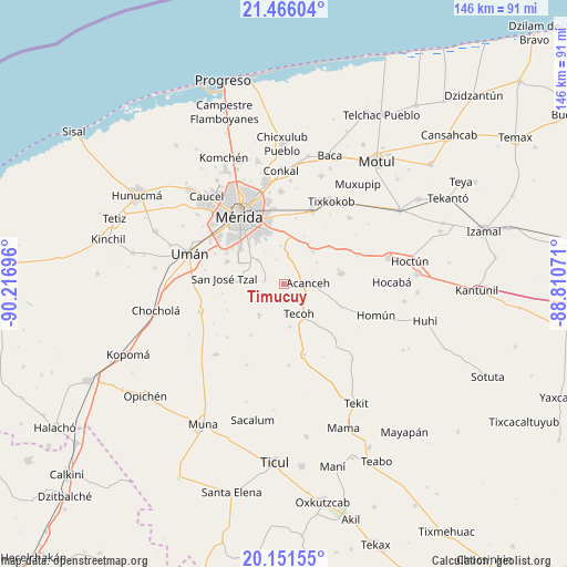
Timucuy GPS coordinates[2]
20° 48' 36.828" North, 89° 30' 49.788" West
| Map corner | latitude | longitude |
|---|---|---|
| Upper-left | 21.46604°, | -90.21696° |
| Center: | 20.81023°, | -89.51383° |
| Lower-right: | 20.15155°, | -88.81071° |
| Map W x H: | 146.2×146.2 km | = 90.8×90.8mi |
| max Lat: | 32.7° ⇑26.6% North |
| Timucuy: | 20.81023° |
| min Lat: | ⇓73.4% South 14.53588° |
| min Long | Timucuy | max Long |
| -117.105° | -89.51383° | -86.73105° |
| W 98.1%⇐ | ⇒1.9% E |
Elevation
Elevation of Timucuy is 16 m = 52 ft, and this is 1237.7 m = 4061 ft below average elevation for this country.
| Max E: |
3497 m = 11473 ft | 93.5% |
| Avg. | 1253.7 m = 4113 ft | |
| Timucuy | 16 m = 52 ft | |
Min E: |
-1 m = -3 ft | 6.5% |
See also: Mexico elevation on elevation.city.
Geographical zone
Timucuy is located in North Torrid zone (between Equator and Tropic of Cancer). Distance of this Northern Tropic circle is 292 km =181.4 mi to North.| Distance of | km | miles | from Timucuy |
|---|---|---|---|
| North Pole | 7693.2 | 4780.3 | to North |
| Arctic Circle | 5087.3 | 3161.1 | to North |
| Tropic Cancer | 292 | 181.4 | to North |
| Equator | 2313.9 | 1437.8 | to South |


Nearby cities:
15 places around Timucuy: (largest is in red/bold)
• Acanceh
6.3 km =3.9 mi,  87°
87°
• Canícab
10.2 km =6.3 mi,  56°
56°
• Lepan
11 km =6.8 mi,  170°
170°
• Molas
12.1 km =7.5 mi,  273°
273°
• Petectunich
5.3 km =3.3 mi,  48°
48°
• San Antonio Tehuitz
10 km =6.2 mi,  356°
356°
• San Pedro Chimay
9.1 km =5.7 mi,  311°
311°
• Subinkancab
6.6 km =4.1 mi,  343°
343°
• Tahdzibichen
12.1 km =7.5 mi, 313°
• Tekik de Regil
5 km =3.1 mi,  278°
278°
• Tekoh
8.5 km =5.3 mi,  150°
150°
• Tepich Carrillo
7.6 km =4.7 mi,  12°
12°
• Ticopó
11.6 km =7.2 mi,  40°
40°
• Xmatkuíl
12.9 km =8 mi,  295°
295°
• Yaxníc
11.2 km =7 mi,  258°
258°
Sources, notices
• [Note1] Compared only with cities in Mexico existing in our database
• [Src1] Map data: © OpenStreetMap contributors (CC-BY-SA)
• [Src2] Other city data from geonames.org with taken over terms of usage.
• [Src3] Geographical zone / Annual Mean Temperature by Robert A. Rohde @ Wikipedia
