San Pedro Chimay geodata
San Pedro Chimay (Yucatán) is a populated place; located in Mexico in America/Merida (GMT-6) time zone. With population of 1,241 people, there are 6992 cities with bigger population in this country. Compared to other cities in Mexico, 74.2% of cities are located further ↓South; 98% of cities are located further ←West and 95.1% of cities have higher elevation than San Pedro Chimay. Note1


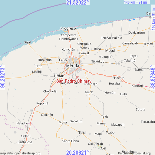
San Pedro Chimay GPS coordinates[2]
20° 51' 52.74" North, 89° 34' 46.56" West
| Map corner | latitude | longitude |
|---|---|---|
| Upper-left | 21.52022°, | -90.28273° |
| Center: | 20.86465°, | -89.5796° |
| Lower-right: | 20.20621°, | -88.87648° |
| Map W x H: | 146.1×146.1 km | = 90.8×90.8mi |
| max Lat: | 32.7° ⇑25.8% North |
| San Pedro Chimay: | 20.86465° |
| min Lat: | ⇓74.2% South 14.53588° |
| min Long | San Pedro Chima | max Long |
| -117.105° | -89.5796° | -86.73105° |
| W 98%⇐ | ⇒2% E |
Elevation
Elevation of San Pedro Chimay is 13 m = 43 ft, and this is 1240.7 m = 4071 ft below average elevation for this country.
| Max E: |
3497 m = 11473 ft | 95.1% |
| Avg. | 1253.7 m = 4113 ft | |
| San Pedro Chimay | 13 m = 43 ft | |
Min E: |
-1 m = -3 ft | 4.9% |
See also: Mexico elevation on elevation.city.
Geographical zone
San Pedro Chimay is located in North Torrid zone (between Equator and Tropic of Cancer). Distance of this Northern Tropic circle is 286 km =177.7 mi to North.| Distance of | km | miles | from San Pedro Chimay |
|---|---|---|---|
| North Pole | 7687.1 | 4776.5 | to North |
| Arctic Circle | 5081.2 | 3157.3 | to North |
| Tropic Cancer | 286 | 177.7 | to North |
| Equator | 2319.9 | 1441.5 | to South |


Nearby cities:
15 places around San Pedro Chimay: (largest is in red/bold)
• Dzununcan
7.7 km =4.8 mi,  270°
270°
• Kanasín
8.1 km =5 mi,  15°
15°
• Leona Vicario
5.5 km =3.4 mi,  335°
335°
• Molas
7.5 km =4.7 mi,  224°
224°
• San Antonio Tehuitz
7.3 km =4.5 mi,  57°
57°
• San José Tzal
9.5 km =5.9 mi,  241°
241°
• Santa Cruz Palomeque
7.9 km =4.9 mi,  283°
283°
• Subinkancab
5 km =3.1 mi,  86°
86°
• Tahdzibichen
3 km =1.9 mi,  321°
321°
• Tekik de Regil
5.7 km =3.5 mi,  160°
160°
• Tepich Carrillo
8.6 km =5.3 mi,  81°
81°
• Teya
10.1 km =6.3 mi,  37°
37°
• Timucuy
9.1 km =5.7 mi,  131°
131°
• Xmatkuíl
4.8 km =3 mi,  264°
264°
• Yaxníc
9.3 km =5.8 mi,  206°
206°
Sources, notices
• [Note1] Compared only with cities in Mexico existing in our database
• [Src1] Map data: © OpenStreetMap contributors (CC-BY-SA)
• [Src2] Other city data from geonames.org with taken over terms of usage.
• [Src3] Geographical zone / Annual Mean Temperature by Robert A. Rohde @ Wikipedia
