Petectunich geodata
Petectunich (Yucatán) is a populated place; located in Mexico in America/Merida (GMT-6) time zone. With population of 600 people, there are 14337 cities with bigger population in this country. Compared to other cities in Mexico, 73.9% of cities are located further ↓South; 98.1% of cities are located further ←West and 94% of cities have higher elevation than Petectunich. Note1


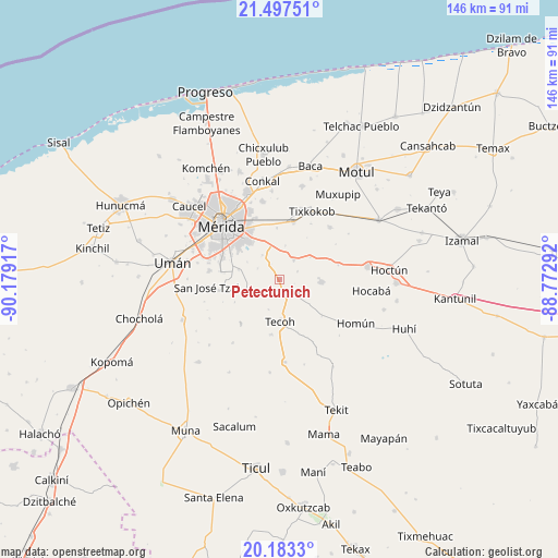
Petectunich GPS coordinates[2]
20° 50' 30.624" North, 89° 28' 33.744" West
| Map corner | latitude | longitude |
|---|---|---|
| Upper-left | 21.49751°, | -90.17917° |
| Center: | 20.84184°, | -89.47604° |
| Lower-right: | 20.1833°, | -88.77292° |
| Map W x H: | 146.1×146.1 km | = 90.8×90.8mi |
| max Lat: | 32.7° ⇑26.1% North |
| Petectunich: | 20.84184° |
| min Lat: | ⇓73.9% South 14.53588° |
| min Long | Petectunich | max Long |
| -117.105° | -89.47604° | -86.73105° |
| W 98.1%⇐ | ⇒1.9% E |
Elevation
Elevation of Petectunich is 15 m = 49 ft, and this is 1238.7 m = 4064 ft below average elevation for this country.
| Max E: |
3497 m = 11473 ft | 94% |
| Avg. | 1253.7 m = 4113 ft | |
| Petectunich | 15 m = 49 ft | |
Min E: |
-1 m = -3 ft | 6% |
See also: Mexico elevation on elevation.city.
Geographical zone
Petectunich is located in North Torrid zone (between Equator and Tropic of Cancer). Distance of this Northern Tropic circle is 288.5 km =179.3 mi to North.| Distance of | km | miles | from Petectunich |
|---|---|---|---|
| North Pole | 7689.7 | 4778.2 | to North |
| Arctic Circle | 5083.8 | 3158.9 | to North |
| Tropic Cancer | 288.5 | 179.3 | to North |
| Equator | 2317.4 | 1440 | to South |


Nearby cities:
15 places around Petectunich: (largest is in red/bold)
• Acanceh
4 km =2.5 mi,  143°
143°
• Canícab
5 km =3.1 mi,  65°
65°
• Kanasín
13.4 km =8.3 mi,  320°
320°
• Sahé
9 km =5.6 mi,  9°
9°
• San Antonio Tehuitz
7.9 km =4.9 mi, 324°
• San Pedro Chimay
11.1 km =6.9 mi,  283°
283°
• Seyé
10.9 km =6.8 mi,  93°
93°
• Subinkancab
6.4 km =4 mi,  296°
296°
• Tahdzibichen
13.6 km =8.5 mi,  291°
291°
• Tekik de Regil
9.3 km =5.8 mi,  252°
252°
• Tekoh
10.9 km =6.8 mi,  178°
178°
• Tepich Carrillo
4.5 km =2.8 mi,  329°
329°
• Teya
11.5 km =7.1 mi,  336°
336°
• Ticopó
6.4 km =4 mi,  34°
34°
• Timucuy
5.3 km =3.3 mi,  228°
228°
Sources, notices
• [Note1] Compared only with cities in Mexico existing in our database
• [Src1] Map data: © OpenStreetMap contributors (CC-BY-SA)
• [Src2] Other city data from geonames.org with taken over terms of usage.
• [Src3] Geographical zone / Annual Mean Temperature by Robert A. Rohde @ Wikipedia
