Leona Vicario geodata
Leona Vicario (Yucatán) is a populated place; located in Mexico in America/Merida (GMT-6) time zone. With population of 2,754 people, there are 3213 cities with bigger population in this country. Compared to other cities in Mexico, 75% of cities are located further ↓South; 98% of cities are located further ←West and 95.1% of cities have higher elevation than Leona Vicario. Note1


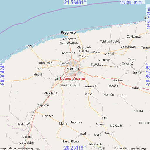
Leona Vicario GPS coordinates[2]
20° 54' 33.984" North, 89° 36' 3.996" West
| Map corner | latitude | longitude |
|---|---|---|
| Upper-left | 21.56481°, | -90.30424° |
| Center: | 20.90944°, | -89.60111° |
| Lower-right: | 20.25119°, | -88.89799° |
| Map W x H: | 146.1×146.1 km | = 90.8×90.8mi |
| max Lat: | 32.7° ⇑25% North |
| Leona Vicario: | 20.90944° |
| min Lat: | ⇓75% South 14.53588° |
| min Long | Leona Vicario | max Long |
| -117.105° | -89.60111° | -86.73105° |
| W 98%⇐ | ⇒2% E |
Elevation
Elevation of Leona Vicario is 13 m = 43 ft, and this is 1240.7 m = 4071 ft below average elevation for this country.
| Max E: |
3497 m = 11473 ft | 95.1% |
| Avg. | 1253.7 m = 4113 ft | |
| Leona Vicario | 13 m = 43 ft | |
Min E: |
-1 m = -3 ft | 4.9% |
See also: Mexico elevation on elevation.city.
Geographical zone
Leona Vicario is located in North Torrid zone (between Equator and Tropic of Cancer). Distance of this Northern Tropic circle is 281 km =174.6 mi to North.| Distance of | km | miles | from Leona Vicario |
|---|---|---|---|
| North Pole | 7682.2 | 4773.5 | to North |
| Arctic Circle | 5076.3 | 3154.3 | to North |
| Tropic Cancer | 281 | 174.6 | to North |
| Equator | 2324.9 | 1444.6 | to South |


Nearby cities:
15 places around Leona Vicario: (largest is in red/bold)
• Dzununcan
7.4 km =4.6 mi,  227°
227°
• Itzincab Palomeque
10.1 km =6.3 mi,  274°
274°
• Kanasín
5.2 km =3.2 mi,  57°
57°
• Molas
10.7 km =6.6 mi,  196°
196°
• Mérida
7.5 km =4.7 mi,  347°
347°
• Opichen
9.3 km =5.8 mi,  298°
298°
• San Antonio Tehuitz
8.4 km =5.2 mi,  97°
97°
• San Pedro Chimay
5.5 km =3.4 mi,  155°
155°
• Santa Cruz Palomeque
6.3 km =3.9 mi,  239°
239°
• Subinkancab
8.6 km =5.3 mi,  122°
122°
• Tahdzibichen
2.6 km =1.6 mi,  172°
172°
• Tekik de Regil
11.1 km =6.9 mi, 158°
• Teya
8.9 km =5.5 mi,  70°
70°
• Ticimul
9.1 km =5.7 mi,  249°
249°
• Xmatkuíl
6 km =3.7 mi, 204°
Sources, notices
• [Note1] Compared only with cities in Mexico existing in our database
• [Src1] Map data: © OpenStreetMap contributors (CC-BY-SA)
• [Src2] Other city data from geonames.org with taken over terms of usage.
• [Src3] Geographical zone / Annual Mean Temperature by Robert A. Rohde @ Wikipedia
